Trimble Business Center FAQ
Starting from version 5, it is now necessary to have a TBC Survey Advanced license to be able to use the Mobile Mapping module, and to export mobile mapping data.
Customers under MX7 warranty can get TBC Advanced free of charge by letting Trimble know the serial number of the system.
The following modules are included in the Mobile Mapping bundle:
- Survey Advanced edition
- GIS
- Scanning
- Mobile Mapping
- MM MX9 Laser Correction
View and download the latest PDF TBC Tech Sheets, which include product features, supported workflows, and system requirements, from Trimble Business Center > Bulletins and Updates > Technical Notes. System requirements are on the last page.
To know what computer specifications required to maximize the processing speed, see these documents:
Although the Sentinel HASP Runtime Library is included in the TBC and Trident installers, sometimes it's necessary to install the latest version. The latest version can be downloaded from here: https://cpl.thalesgroup.com/software-monetization/sentinel-drivers.
Click Sentinel LDK Runtime & Drivers and select the latest version of Sentinel HASP/LDK Windows GUI Run-time Installer.
Installing this will install a service called Sentinel LDK License Manager. This is required for hosting TBC and Trident licenses.
Before version 5 a license was not required. Since version 5, TBC Survey Advanced is required.
Geoids must be in .ggf format and are imported in Trimble Coordinate System Manager.
If the geoid is available in another format, you can try to convert it with the Trimble Grid Factory. The File / Import Grids menu option can then be used to import your ASCII file. This option provides a wizard that you can use to define the way the file is to be read including the latitude and longitude extents of the file and the interval between points etc.
Access context sensitive help on the different fields in the wizard by pressing F1.
For requests to add or change existing items in Trimble Coordinate System Manager, use this form.
Select the option to generate cache on import. This will produce the cubical images in the TBC project folder. Then you can select MX7 Export to Cubical to export the panorama.csv and trajectory.csv. Use the cubical images located in the TBC project folder.
The latitude, longitude, altitude refer to the optical center of the side cameras, and a virtual camera center for the panoramic camera. Those centers are typically the offset that you can find in the extrinsic calibration parameters of the cameras in the extcal.json file, relative to the MX9 body frame.
For more details about the Ladybug camera center, refer to the Ladybug5 Technical Reference, page 97, chapter C.1.3. The Panoramic camera calibration in TBC is done using a Cubic projection (page 101,102).
Last modified
10 February 2022
Yes. Simply load multiple missions (.mxdb), then generate the desired scans from these missions.
Scans can be exported from one project using Point Cloud exporter / TDX exporter (Trimble RealWorks), then imported into another project.
Currently, the Batch Register Run to Run module in TBC 5.40.1 doesn't allow registering a run to a run from another mission. The workaround is to use the CAD module to generate fake control points from the first run, and then register the 2nd run to these fake control points.
Yes. Use Ctrl+mouse scroll.
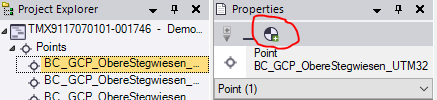
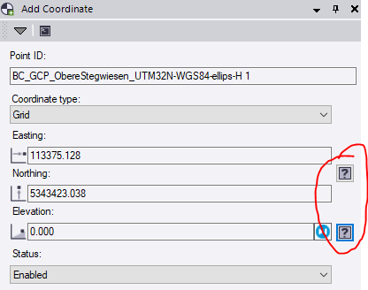
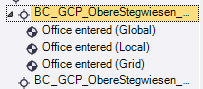
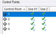
In TBC 5.11 only, points need to have their coordinates set to control quality in order to be used as control points in registration. To do so, click add coordinate, and set it to control quality.
For the MX7, only CPU and RAM are used to visualize the data.
The GPU is needed to visualize the point clouds, and to export images.
Last modified
17 June 2021
