Capturing remote features
 In some situations you are unable to get close to the feature or asset you are collecting or updating. For example, the feature could be located behind a fence or on the surface of a busy road. In this situation, you can capture the remote feature using a laser rangefinder connected to your device. The laser rangefinder measures the distance to the feature from your current position and this distance is stored as an offset position.
You can also use a laser rangefinder to speed up your data collection workflow if you have several features to collect and a clear line of sight to them all. Stand in one location and use the laser rangefinder to capture the position of each feature. This saves you having to walk up to each feature to log its position.
TerraFlex supports the following laser rangefinders:
-
With iOS devices:
-
LaserTech TruPulse 200X laser rangefinder
-
-
With Android or Windows devices:
-
LaserTech TruPulse 200 laser rangefinder
-
LaserTech TruPulse 200X laser rangefinder
-
LaserTech TruPulse 360° laser rangefinder
-
To pair the rangefinder with your device
-
Press the power button on the rangefinder.
-
Make sure Bluetooth is enabled on the rangefinder. For more information, refer to the manufacturer's instructions.
-
On your device, go to the Bluetooth settings screen and pair with the rangefinder.
-
Connect to the rangefinder in the TerraFlex software.
To connect to the rangefinder in TerraFlex
-
Once you have paired your device with the rangefinder, in TerraFlex tap
 and tap Settings.
 -
Tap the Laser Rangefinder tile. From the list of Available Devices, tap the rangefinder your device is paired with. If the rangefinder is not listed, tap the Refresh icon at the top of the Available Devices list.
When the rangefinder is connected, the software returns to the Settings screen.
-
To accurately capture the height of features captured remotely, tap Laser Height and enter the height of the rangefinder.
The Laser Height value is the distance from the ground to the bottom of the laser when it is mounted on the pole you are using. If you are not using a pole it is the distance from the ground to the bottom of the laser at the height at which the rangefinder is used (your eye height).
-
Make sure the antenna height of the GPS receiver is correct. Tap Antenna Height and enter the distance from the ground to the bottom of the antenna when it is mounted on the pole you are using.
The type of offset measured by the TerraFlex software depends on the capabilities of the connected laser rangefinder: When connected to:
-
A LaserTech TruPulse 200 or 360° laser rangefinder, the TerraFlex software uses the bearing sensor in the laser rangefinder to measure a distance‑bearing offset.
-
A LaserTech TruPulse 200X laser rangefinder, the TerraFlex software always measures a distance‑distance offset.
To measure a distance‑bearing offset
-
Make sure the rangefinder is operating one of the available distance modes, that is SD (Slope Distance), HD (Horizontal Distance) or VD (Vertical Distance) mode. For more information, refer to the manufacturer's instructions.
-
In the map, tap
 . When TerraFlex is connected to a rangefinder, the Collect Offset wizard opens.
 -
Move to the location you want to use as a starting point and log your current position.
-
Use the rangefinder to measure the offset from your current position to the asset you are capturing.
-
If the captured offset is within the accuracy threshold, or outside the accuracy threshold but you can allow it, tap Accept.
- If the captured offset is outside the accuracy threshold and you are not permitted to accept it, tap Refine. Move 90 degrees around the asset and repeat steps 2 through 4 above.
- To save the collected offset, tap
 .
.
To measure a distance‑distance offset
-
 Make sure the rangefinder is operating one of the available distance modes, that is SD (Slope Distance), HD (Horizontal Distance) or VD (Vertical Distance) mode. For more information, refer to the manufacturer's instructions.
 -
In the map, tap
. When TerraFlex is connected to a rangefinder, the Collect Offset wizard opens. -
Move to the location you want to use as a starting point and log your current position.
-
Use the rangefinder to measure the offset from your current position to the asset you are capturing.
-
Move 90 degrees around the asset and log another position.
-
Use the rangefinder to measure the offset from your position to the asset you are capturing.
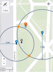
The software uses the two reference positions you logged and the distance values from the rangefinder measurements to calculate two intersecting circles that show the two possible locations of the asset and shows them on the map. The two reference positions are indicated by the blue map pins and the two possible asset locations are the two solid yellow discs.
-
From the two highlighted asset locations on the map, tap the solid yellow disc that is the correct location of the asset. If you are not sure which location is correct, walk toward the asset.
-
If you are not able to get closer to the asset, or if the selected location is outside the accuracy threshold and you are not permitted to accept it, tap Restart and then repeat steps 4 through 6 above.
-
To save the collected offset, tap
.
If the software is unable to calculate a good position, an alert appears at the top of the screen. Tap the alert to view more information about the issue and the steps you can take to reduce the error. The most common issues when using a laser rangefinder are when magnetic disturbance is detected, such as when you are near metallic objects, or a bearing error. In these cases the alert will suggest moving to a different location to retake the measurement.
