Site calibration
Calibration is the process of adjusting projected (grid) coordinates to fit the local control. A calibration calculates parameters for transforming WGS‑84 coordinates into local grid coordinates (NEE).
You should calculate and apply a calibration before:
- staking out points
- computing offset or intersection points
If you calibrate a project and then survey in real time, the General Survey software gives real-time solutions in terms of the local coordinate system and control points.
Use Trimble Access to perform a calibration using a least squares computation and calculate either a horizontal and vertical adjustment, or a Transverse Mercator projection and a 3‑parameter datum transformation, depending on what the coordinate system settings that have already been defined in tthe job. Each method results in the computation of different components, but the overall result is the same if enough reliable control points (coordinates in your local system) are used. The two methods are:
-
If you used published datum transformation parameters and map projection details when you created a job, and if you provide enough control points during the calibration, then during calibration the software calculates horizontal and vertical adjustments. Horizontal control points allow scale error anomalies in the map projection to be removed. Vertical control allows local ellipsoid heights to be transformed into useful orthometric heights.
Always use published parameters if they exist.
- If you did not know the map projection and datum transformation parameters when you created the job and so you selected No projection / no datum and if you specified that ground coordinates were required, then during calibration the software calculates a Transverse Mercator projection and a Molodensky three‑parameter datum transformation using the supplied control points. The project height you specified when creating the job is used to compute a ground scale factor for the projection so that ground coordinates are computed at that height.
The following table shows the output of a calibration when various data is supplied.
| Projection | Datum transformation | Calibration output |
|---|---|---|
| Yes | Yes | Horizontal and vertical adjustment |
| Yes | No | Datum transformation, horizontal and vertical adjustment |
| No | Yes | Transverse Mercator projection, horizontal and vertical adjustment |
| No | No | Transverse Mercator projection, zero datum transformation, horizontal and vertical adjustment |
- If no datum and no projection are defined, you can only stake out lines and points that have WGS‑84 coordinates. Displayed bearings and distances are in terms of WGS‑84.
- Specify a projection before staking out arcs, roads, and DTMs. The Trimble Access software does not assume that WGS‑84 is the local ellipsoid, so you must also define a datum.
- Without a datum transformation, you can only start a real‑time base survey with a WGS‑84 point.
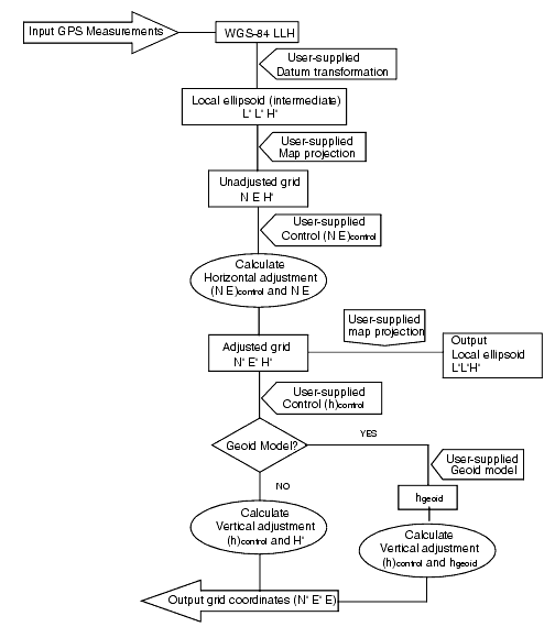
The following diagram shows the order of calculations performed when a calibration is calculated.

Trimble recommends that you observe and use a minimum of four local control points for the calibration calculation. For best results, local control points should be evenly distributed over the job area as well as extending beyond the perimeter of the site (assuming that the control is free of errors).
Apply the same principles as you would when placing control for photogrammetric jobs. Make sure that the local control points are evenly distributed to the extent of the job area.
You can reuse the calibration from a previous job if the new job is completely encompassed by the initial calibration. If a portion of the new job lies outside the initial project area, introduce additional control points to cover the unknown area. Survey these new points and compute a new calibration, and then use this as the calibration for the job.
To copy the calibration from an existing job to a new job, select the existing job as the current job and then create a new job and in the Template field select Last used job. Alternatively, use the Copy between jobs function to copy the calibration from one job to another.


