Units
To configure units and formats for numerical values for the job:
- Tap
and select Job. The current job is already selected.
- Tap Properties.
- Tap Units.
- Change the fields as required.
Some fields in the Trimble Access software allow you to enter a value in units other than the system units. When you enter a value in one of these fields (for example Azimuth) and tap Enter, the value is converted to the system units.
| This setting | Specifies how the following values are displayed |
|---|---|
|
Distance and grid coords |
Distance and northing/easting coordinates |
|
Height |
Height and elevation |
|
Angles |
Angles |
|
Quadrant bearings |
Bearing values are automatically converted to quadrant bearings when this check box is enabled. For example, to enter the quadrant bearing N25° 30' 30"E in a bearing field, key in 25.3030 and then tap |
|
Temperature |
Temperature |
|
Pressure |
Pressure |
|
Grade |
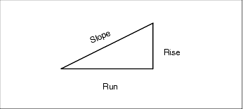
Grade The grade of a slope can be displayed as an angle, percent, or ratio. The ratio can be displayed as Rise:Run or Run:Rise.
|
|
Area |
Supported area units include:
|
|
Volume |
Supported volume units include:
|
| This setting | Specifies how the following values are displayed |
|---|---|
|
Distance display |
The number of decimal places in all distance fields. When the Distance and grid coordinates field is set to US survey feet or international feet you can configure the distance display to be in feet and inches. Supported fractions of an inch include: 1/2", 1/4", 1/8", 1/16" and 1/32". |
|
Coordinate display |
The number of decimal places in all northing/easting coordinate fields |
|
Area display |
The number of decimal places for a computed area |
|
Volume display |
The number of decimal places for a computed volume |
| Angle display |
The number of decimal places for a computed angle. |
|
Lat / Long |
Latitude and longitude |
|
Coordinate order |
The order for the displayed grid coordinates. Select from:
For the Y‑X‑Z and X‑Y‑Z options, the convention used defines that the Y axis is the East axis and the X axis is the North axis. |
|
Station display |
(Also known as Chainage in some countries.) This defines the distance along a line, arc, alignment, road or tunnel. The station values can be displayed as:
The Station index display type uses an extra Station index increment field value as part of its definition. The station value is displayed as per the 10+00.0 option, but the value before the + is the station value divided by the Station index increment. The remainder is displayed after the +. For example if the Station index increment is set to 20, a station value of 42.0 m is displayed as 2 + 02.0 m. This display option is used in Brazil but may have application in other markets. |
|
Station index increment |
If the Station display is set to Station index the station index increment field appears enabling an appropriate station index increment to be entered. See details above. |
|
Laser VA display |
Laser vertical angles Can be vertical angles measured from the zenith, or inclinations measured from horizontal. |
|
Time format |
The format for date and time. Select from:
|


