Base station coordinates
For an RTK survey, the base station coordinates must be Global coordinates, that is the coordinates must be in the Global reference datum at the Global reference epoch. The Global reference datum and the Global reference epoch are shown in the Select coordinate system screen of the job properties. See Coordinate system.
The coordinates you enter should be as accurate as possible. Every 10 m of error in a base station coordinate can introduce a scale error on every measured baseline of up to 1 ppm.
The following recognized methods, listed in descending order of accuracy, are used to determine base station coordinates:
- Published or precisely‑determined coordinates.
- Coordinates computed from published or precisely‑determined grid coordinates.
- Coordinates derived using a reliable differential (RTCM) broadcast based on published or precisely‑determined coordinates.
- An SBAS position generated by the receiver. Use this method if no control exists for the location and you have a receiver that tracks SBAS satellites.
- An autonomous position generated by the receiver. Use this method for real‑time surveys in a location where no control exists. Trimble strongly recommends that you calibrate any jobs started by this method on a minimum of four local control points.
If the keyed in coordinates differ from the current autonomous position generated by the receiver by more than 300 m, a warning message appears.
Survey integrity
To preserve the integrity of a GNSS survey, consider the following:
-
When you start subsequent base receivers for a particular job, make sure that each new base coordinate is in the same terms as the initial base coordinate.
Within a job, only use an autonomous position to start the first base receiver. An autonomous position is equivalent to an assumed coordinate in conventional surveying.
- Coordinates published by a reliable source and coordinates determined by control surveys should be in the same system.
- If subsequent base coordinates are not in the same terms, regard observations from each base as a separate job. Each needs a separate calibration.
- Because measured real‑time kinematic points are stored as vectors from the base station, not as absolute positions, the origin of the survey must be an absolute position in the Global reference datum from which the vectors radiate. If other base stations are subsequently set up on points measured from the original base station, all vectors are resolved back to the original base station.
- It is possible to start the base on any kind of coordinates, for example, grid or local ellipsoid coordinates. However, in a real‑time survey, the Trimble Access software must store a position in the Global reference datum for the base when a rover survey is started. It is this position that is held fixed as the origin of the network.
When you start a rover survey, the Trimble Access software compares the position broadcast by the base receiver with points already in the database. If a broadcast point has the same name as a point in the database, but different coordinates, the Trimble Access software uses the coordinates that are in the database. These coordinates were keyed in or transferred by you, so it assumes that you want to use them.
If a point in the database has the same name as the one being broadcast by the base, but the coordinates are NEE or local LLH rather than Global coordinates, the Trimble Access software converts this point to Global coordinates using the current datum transformation and projection. It then uses these as the base coordinates. If no datum transformation and projection are defined, the broadcast Global point is automatically stored and used as the base.
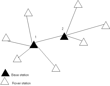
The following diagram shows a survey using two base stations.
In this survey, Base station 2 was first surveyed as a roving point from Base station 1.
Base stations 1 and 2 must be linked together by a measured baseline, and Base station 2 must be started with the same name that it had when it was surveyed as a roving point from Base station 1.