Magnetometer tilt compensation
Trimble R10 and R12 receivers have a built-in magnetometer that allows you to measure points with a tilted pole using the Compensated point method.
Compensated points
The compensated point measurement method uses the tilt sensor and magnetometer built into the receiver to compute the position of the pole tip. The Compensated point method appears in the list of available measurement methods during a GNSS survey when the Tilt functions check box is enabled in the Rover options screen of the survey.
Measuring a compensated point is useful when:
- You want to measure point more quickly without spending time making sure the pole is level.
- An obstruction means that you are unable to position the antenna directly above the point. Traditionally you would need to use an offsetting technique to measure such points. Using the compensated point measurement method corrects the antenna's offset location to produce a ground position at the tip of the pole.
When measuring a compensated point, the tilt sensor measures the tilt of the antenna and calculates the offset from the pole tip. The graduations in the eBubble vial represent the sphere through which the antenna moves when the pole tip is stationary. For example:
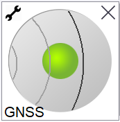
| Bubble color | Tilt range | Meaning |
|---|---|---|
| Green | < 12 degrees | You are within the tilt tolerance for a compensated point. |
| Yellow | 12 to 15 degrees | You are close to exceeding the tilt tolerance for a compensated point. |
| Red | > 15 degrees | You have exceeded the tilt tolerance for a compensated point. |
Magnetic disturbance
The system attempts to detect the amount of magnetic disturbance in the environment by comparing the sensed magnetic field with the expected magnetic field. The expected magnetic field comes from a model of the earth's magnetic field stored in the receiver. The magnetometer senses the magnitude (strength) and the vertical direction (inclination angle) of the environment's magnetic field and compares it to the expected magnitude and vertical direction for the location. If the values do not match, then magnetic disturbance is detected.
The level of magnetic disturbance is indicated by the Magnetic disturbance value, which uses a scale from 0 to 99. The level of magnetic disturbance is also reflected in the precision estimate. If you have correctly calibrated the magnetometer and are working in an environment free of magnetic interference, then you should see magnetic disturbance values lower than 10.
If the value is higher than 50, a warning is displayed on the status line. If the value is 99 you will not be able to store the point unless the pole's tilt distance is within 1 cm of level. Check the vicinity for sources of magnetic interference. If there are there are no obvious sources of magnetic disturbance, check your calibration.
You can view the Magnetic disturbance value for a point in the Review Job screen.
In magnetically disturbed environments it is possible for the magnetometer to sense the expected magnitude and vertical direction values but an incorrect horizontal direction. It is impossible to detect this. If this happens, the software reports low magnetic disturbance values when in fact there are large magnetic azimuth errors. To avoid these errors, it is important to use compensated points only in areas free of magnetic disturbance.
Only the horizontal position is dependent on the magnetometer. If your survey requires high vertical accuracy but horizontal accuracy is less important, then magnetic interference may be less significant. The horizontal quality of the point degrades more at a higher tilt angle with higher magnetic disturbance. In other words, magnetic disturbance has no effect if the pole is level.
