To measure a MultiTilt point
Use the MultiTilt point measurement method to measure a point using three contributing tilted eBubble measurements.
MultiTilt is available only when using a receiver with an eBubble and when Tilt functions are enabled in the survey style. To be able to measure MultiTilt points the GNSS receiver must have a properly calibrated eBubble. The MultiTilt point measurement method is not available in data logging surveys or when IMU tilt compensation is active.
The MultiTilt point measurement method does not use a magnetometer. If your GNSS receiver has one, the magnetometer does not need to be calibrated before using MultiTilt.
When you measure a MultiTilt point, you position the tip of the pole at the desired measurement location, and keep the pole tip fixed at the same location during the entire measurement process. Tilt the pole first in one direction and measure, tilt the pole in the second direction and measure, and then tilt the pole in the third direction and measure.

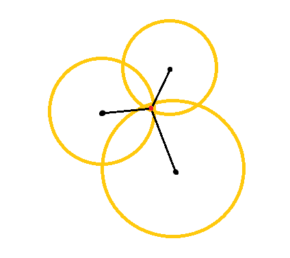
The diagram above shows the three tilt circles that are created when you tilt the antenna to three different positions, where each antenna position is indicated by a black dot at the center of each tilt circle. The tilt circles have a radius equal to the current tilt distance, and each tilt circle represents the circle of possible locations of the pole tip at that distance from the antenna position. To calculate the location of the pole tip, the software calculates the point at which the three tilt circles intersect.
The steps below guide you through measuring three tilted observations, where the software automatically measures when the pole is held still, and computes the resulting point using the intersections of the three tilt circles observed with the tilted pole:
- Tap
and select Measure / Measure points, or in the map, with nothing selected, tap Measure.
- Select MultiTilt point from the Method field.
-
Enter the Point name and Code.
-
If the selected code has attributes, the Attrib softkey appears. Tap Attrib and fill out the attribute fields. See To enter attribute values when measuring a point. Tap Store.
-
Enter a value in the Antenna height field and make sure that the setting in the Measured to field is set appropriately.
Antenna height is critical in the MultiTilt computations. Make sure the entered antenna height and measurement method is set correctly before beginning a MultiTilt point measurement.
-
To configure the quality control and precision settings, tap Options.
The precisions shown in the status line reflect the amount of tilt of the antenna. If measuring points with large amounts of tilt, you may need to increase the precision tolerance setting.
-
Position the tip of the pole at the desired measurement location. Do not move the tip through the entire measurement process.
-
Keeping the pole tip at the desired measurement location, tilt the pole to the desired angle.
The eBubble shows the amount of tilt of the antenna.
The eBubble turns yellow if the tilt exceeds 30 degrees. This indicates when the precision of the RTK solution produced may become unreliable due to the tilt being outside the acceptable tilt range for non-IMU tilt compensated positions. The measurements in this range may remain usable if the precision estimates are acceptable to you. The eBubble turns red if the tilt exceeds 45 degrees.
-
Tap Measure.
The MultiTilt status field indicates the process of taking three tilted rapid point measurements. It shows Waiting to measure when the antenna is moving, Move antenna when a measurement has been taken and the software is waiting for the antenna to move an acceptable amount for another measurement to be taken, and Measuring – hold still when the antenna is being held completely still while tilted.
-
To ensure good intersection geometry of the three contributing measurements, move the antenna as much as practicable between the three stationary measurements, so that the three antenna positions form a triangular shape rather than a straight line.
The counter indicates the remaining number of stationary measurements. The map shows yellow circles representing the three tilt measurements, and a cross representing the result once the third measurement is taken.
-
When the result has been computed and the precisions are acceptable, tap Store.
If the precision of the resulting intersection is not acceptable, tap Esc to discard the three measurements and then remeasure the MultiTilt point.
If the antenna height is correct and the eBubble is properly calibrated, the resulting intersection of the three circles should be centimeter-level. If the circles do not overlap at a discrete point or the precisions are too high:
-
Check your eBubble calibration is of high quality, and make sure that the entered antenna height and measurement method are correct. You cannot correct for these errors after storing a MultiTilt point.
-
Remeasure the point, changing your points of measurement by tilting further away or even a bit closer.