Station coordinates and instrument height
When performing a station setup at the start of a survey you are prompted to enter the coordinates of the point (station) where you have set up the instrument and the instrument height.
Station coordinates
If you have set up the instrument on a known point and the point is available from a linked file, select the linked file for the job and then enter the point name in the Instrument point name or Backsight point name field. The point is automatically copied to the job.
If the coordinates for the instrument point are not known but there are nearby known points, perform a Resection to the known points to obtain the coordinates for the instrument point.
If you cannot determine the coordinates for the instrument point and/or backsight point, you can key them in or measure them later using GNSS (provided that there is a valid GNSS site calibration). The coordinates of any points measured from that station are then computed.
If you enter the instrument point later, make sure that you choose to overwrite the original instrument point in the Duplicate point form. The coordinates of any points measured from that station are then computed.
You can use the Point manager to edit the coordinates of the instrument point and/or backsight point. If you do, then the positions of all records that are computed from that station setup position may change.
Instrument height
The value you enter in the Instrument height field depends on the instrument you are using and whether you are measuring the true height of the instrument or to the Bottom notch on the instrument. The default method is to measure the true height of the instrument.
![]() and then select Bottom notch. When measuring to the notch on a Trimble SX10 or SX12 scanning total station, tap
and then select Bottom notch. When measuring to the notch on a Trimble SX10 or SX12 scanning total station, tap ![]() and then select Bottom notch (SX).
and then select Bottom notch (SX).
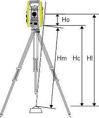
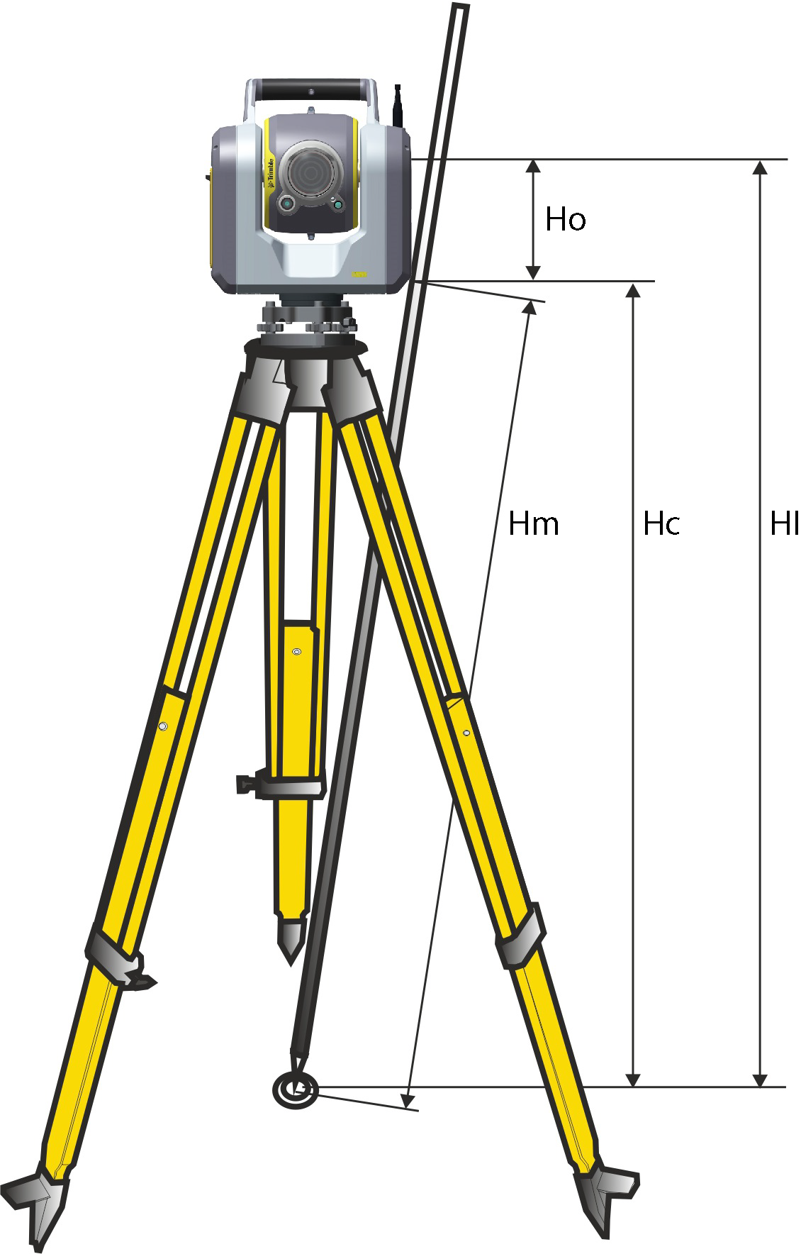
| Value | Definition |
|---|---|
|
Ho |
Offset from the Bottom notch to trunnion axis. The value of the offset depends on the connected instrument:
|
|
Hm |
Measured slope distance. |
|
Hc |
Hm corrected from slope to true vertical. |
|
HI |
Hc + Ho. True vertical instrument height. |
- If you select Bottom notch or Bottom notch (SX), the minimum slope distance (Hm) that you can enter is 0.300 meters. This is approximately the minimum slope distance that can be physically measured. If the minimum is not low enough, you must measure the true height to the top mark.
- For a 2D or planimetric survey, leave the Instrument height field set to null (?). No elevations are calculated. Unless you are using a Scale only projection, a project height must be defined in the coordinate system definition. The Trimble Access software needs this information to reduce measured ground distances to ellipsoid distances and to compute 2D coordinates.
