Catch point
The catch point applies only when staking from a road design file. A catch point does not apply when staking Strings and surfaces.
The catch point is the point where the design side slope intersects with the ground.
The actual intersection position of the side slope with the existing ground surface – the catch point – is determined iteratively (by repetition). The software calculates the intersection of a horizontal plane passing through the current position, and either the cut or fill side slope, as shown in the following diagram , where x n is the Go Right/Left value.
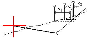
The plan view shows the calculated catch position. The calculated slope value (in blue) and the design slope value appears at the top of the screen.
The cross section is displayed looking in the direction of increasing station. Your current position and the calculated target are indicated. A line is drawn (in blue) from the hinge position to your current position to indicate the calculated slope.
Green lines indicate if the catch point has construction offsets specified. The smaller single circle indicates the calculated catch position and the double circle indicates the selected position adjusted for the specified construction offset(s). The construction offsets appear only after you have applied them.
For side slope offsets where the slope changes between templates, the software calculates the side slope for intermediate stations by interpolating the slope value.
Catch point staked deltas
To view the Catch point deltas report screen, tap Report in the Confirm staked deltas screen or Review job screen.
The horizontal and vertical distances from the catch point to each string are shown, up to and including the horizontal alignment. If the template includes a cut ditch, the report includes the hinge position at the toe of the cut slope. The reported values exclude any construction offset specified.
See the diagram below:
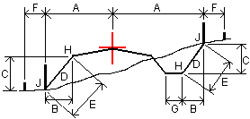
Where:
| A | = | Distance to horizontal alignment |
| B | = | Horizontal distance to hinge point |
| C | = | Vertical distance to hinge point |
| D | = | Slope |
| E | = | Slope distance to hinge point |
| F | = | Horizontal construction offset |
| G | = | Ditch offset |
| H | = | Hinge point |
| J | = | Catch point |
- When you stake a fill side slope with a subgrade, the as staked deltas include the distance from the catch to the intersection of the subgrade with the side slope.
- The value in the S.Dist to hinge + Constr off field includes any construction offset values specified and reports the slope distance from the hinge to the as‑staked position. The value is null (?) if there is no horizontal construction offset specified or the horizontal construction offset is applied horizontally.
