LandXML string roads
LandXML string roads are predefined ready to review and stakeout when you export them from your office software. See:
- To export LandXML string roads from Trimble Business Center
- To export LandXML string roads from Tekla Civil
- To export LandXML string roads from Trimble Novapoint
- To export LandXML string roads from Autodesk Civil 3D
Unlike LandXML cross section roads, LandXML string roads are not stored as RXL roads, and remain XML files when used in the Trimble Access Roads software.
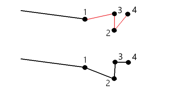
When defining the road in the office software, Trimble recommends that you avoid vertical faces. When one string has the same offset as another, the Roads software can connect the strings in the wrong order when it joins the strings to display the cross sections. To avoid this issue, define one of the strings with a slight offset from the other. For example, consider the following image showing a cross section view of a kerb and channel, where strings 2 and 3 in the upper diagram have the same offset and can, potentially, be connected incorrectly as shown by the red linework. In the lower diagram, where string 3 is defined at a slight offset from string 2, the strings will always be connected correctly as shown by the black linework.

If a file has invalid spiral geometry the horizontal alignment is adjusted using the following rules:
-
For spirals the radii and lengths values in the file are retained but the end coordinates are adjusted to fit.
-
For arcs the radii values in the file are retained but the lengths and coordinates are adjusted to fit.
Advantages of LandXML string roads
LandXML string roads are very similar to GENIO string roads but offer a number of advantages:
- There is no need to select the strings to define the road as the road definition is complete and ready for review and stakeout.
- String names are not limited to 4 characters.
-
LandXML files can include more than one road.
- LandXML files can include more than one surface.
- Support for LandXML string files is better when exporting from Trimble Business Center, and when displaying files or staking with Trimble Access Roads.
While the traditional LandXML string format does not include support for side slopes, Trimble has extended the LandXML format to include support for side slopes. LandXML string files exported from Trimble Business Center will have the side slopes defined. Side slopes can also be defined or modified in the Trimble Access Roads software.
Editing LandXML string roads
To edit a LandXML string road, select the road in the map and tap the Edit softkey. You can:
- Review the geometric elements that define the horizontal and vertical alignments.
-
View the list of the strings that define the road.
A string listed in red text indicates the string goes back on itself and it should not be used with the road. Use the Exclude option to exclude the string from the road.
- Define or edit additional strings.
- Define or edit additional points.
- Exclude strings.
- Convert the outermost left and/or right strings to side slopes.