Stakeout navigation
During stakeout the software helps you to navigate to the selected position on the road. The display orientation assumes you are moving forwards at all times.
Select the display orientation when defining your survey style or, when in a survey, from the Options softkey. The options are:
- Direction of travel – the screen will orientate so that the top of the screen points in the direction of travel.
- North – the screen will orientate so that the north arrow points up the screen.
- Reference azimuth – the screen will orientate to the azimuth of the road.
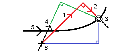
As shown in the diagram below, the values in the Go Forward/Go Backward (1) and Go Right/Go Left (2) fields are relative to the cross‑section of the point that you are staking out (3). They are not relative to the current direction of travel (4), or to the direction of increasing station (5) at your current position (6).

The behavior at stake out differs depending on whether the offset/string was selected graphically, selected from a list, or keyed in.
- If you graphically select a string or select a string from the list, the Go Right/Go Left value at stakeout updates to reflect any changes in geometry due to template changes or widening.
- If you key in a numeric offset value (effectively defining a string on the fly) that value is maintained for the entire length of the road.
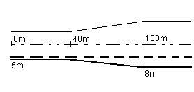
Consider the following diagram:

If you select an offset/string that has an offset value of 5 m, the offset value updates to follow the solid line for subsequent stations. In this example, the offset changes from 5 m to 8 m between stations 40 m and 100 m and then is maintained at 8 m for subsequent stations.
If you key in 5 m for the offset, the offset follows the dashed line. That is, the offset of 5 m is maintained for subsequent stations.