2019.00
Version 2019.00 of the Trimble Access software was released in May 2019. To download these release notes as a PDF file, click this link.
These Release Notes describe the new features and changes available in this release of the Trimble® Access™ software.
64-bit operating system support
Trimble Access version 2019.00 is now a 64-bit application and the following apps are available now: General Survey, Roads, Tunnels, Mines and Pipelines. Additional applications such as Monitoring are coming soon.
Trimble Access version 2019.00 can only be installed to 64-bit controllers. Supported Trimble controllers – the Trimble TSC7 controller and the Trimble T7 and T10 tablet – are 64-bit. If you install Trimble Access to a desktop computer, laptop, or third-party tablet, you will need to ensure it is 64-bit. Most computers manufactured in the last 10 years are 64-bit.
New hardware support
Trimble T7 tablet support
Trimble Access version 2019.00 supports the new Trimble T7 tablet, which provides all the capabilities of the Trimble TSC7 controller in an ultra-rugged tablet form factor. The T7 tablet features a high-definition 7 inch multi-touch screen, 4 programmable function keys, Windows 10 Professional operating system, 8 GB RAM and 128 GB internal storage.
New features
Support for web map services (WMS)
You can now add data from one or more web map services (WMS) to the map. Web map services are an easy way to provide context to the data in your map without having to prepare background map files such as .jpgs or .tif files to cover the project area.
Available web map services depend on your location. To use a web map service, add the WMS and enter the URL you use to retrieve data from the service. Trimble Access saves the configuration information for each WMS in a .wms configuration file in the Trimble Data / System Files folder.
When connected to the WMS, you can control the visibility of WMS data (including sublayers) in the Active map screen.
For more information, see the topic Web map services (WMS) in the Trimble Access Help.
CAD toolbar for creating linework in the map
Trimble Access 2019.00 includes the CAD toolbar in the map. The CAD toolbar enables you to easily use control codes to create line, arc, and polygon features in the map as you measure points, or by drawing features using points already in the job. The tools available on the CAD toolbar depend on whether the CAD toolbar is in Measure mode or Drawing mode.
The CAD toolbar is similar to the one supported on tablets with pre-2018.00 versions of Trimble Access, but is now available to all controllers and can be used with all measurement forms including Measure codes and the Video screen.
CAD toolbar buttons for each feature geometry control code supported by Trimble Access are available. You can now easily create lines, arcs, smooth curves, rectangles or circles, and define horizontal or vertical offsets by tapping the appropriate toolbar button and selecting the line feature code you want to use to identify the feature.
You can easily configure the available CAD buttons on the toolbar by tapping and holding on a button and selecting the new button.
To use the CAD toolbar, the currently selected feature library must contain definitions for the required control codes, and the feature code assigned to the feature must be defined as a line.
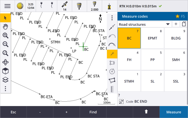
For more information, see the topic CAD toolbar in the Trimble Access Help.
Enhancements
SX10 scan data display enhancements
Trimble Access 2019.00 includes the following enhancements for scan data captured using a Trimble SX10 scanning total station:
- Trimble Access now has dynamic detail loading of point clouds depending on the field of view, so that when you zoom in, the software dynamically loads more details from the zoomed in area.
- Trimble Access can now handle jobs that contain a very large number of SX10 scan points. The size of the job is now effectively only limited by the amount of space available on the controller.
- Two new color modes for scan point clouds shown in the map or video screen. You can now color the point cloud to indicate the elevation of points or the reflective intensity of points using a color (the reflective intensity of points using gray scale was already supported).
The following images show the same scan data in previous versions of Trimble Access (left) and with dynamic detail loading in version 2019.00 (right):
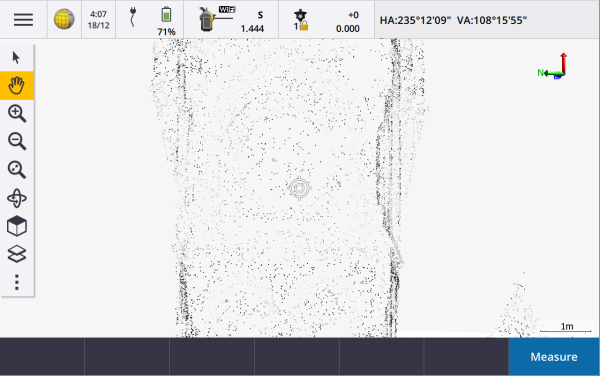
|
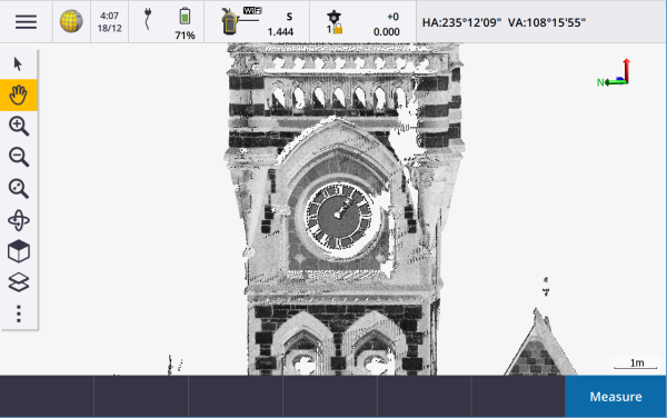
|
Favorites and Functions enhancements
Favorites and Functions enable you to create shortcuts to software screens, map controls, or to enable/disable an instrument or receiver function.
In Trimble Access 2019.00, you can create groups of favorites and functions and then use the group that matches your workflow. For example you might use one group when using an SX10 scanning total station and another group when using an R10 receiver. Favorites are accessible from the Favorites screen. Activate a function by pressing the appropriate function key. When using groups the function that is enabled when you press F3 for example, depends on whether you are using the SX10 or the R10 group of functions.
We have added more functions to the Assign special functions list. To assign a function key shortcut to a software function for which there is no ![]() icon, tap
icon, tap ![]() in the Favorites screen and tap + on the function key you want to use and select the function you want to assign. Some of the newly added functions include:
in the Favorites screen and tap + on the function key you want to use and select the function you want to assign. Some of the newly added functions include:
- Softkey 1-4: Actions the command on the corresponding softkey in the current screen (1 through 4, left to right).
- Zoom level: When connected to an SX10, zoom to your preferred zoom level. Configure more than one if you frequently switch between a couple of zoom levels.
- View area of interest: Return to the map view you have set as the area of interest.
- Toggle Solid/Wireframe IFC: Switch between displaying IFC models as solid objects or wireframe.
For more information, see the topic Favorite screens and functions in the Trimble Access Help.
IFC file enhancements
Trimble Access 2019.00 includes the following enhancements for IFC files:
- Faster reloading of IFC files once the file has been used in Trimble Access, even when reopening the job or using the same IFC file in a different job.
- You can now compute the center point of a surface in an IFC model. To do this, select the surface in the map and then select Compute center point from the tap and hold menu. This is useful to find the center point of a bolt or cylinder so you can then stake it out.
- You can now measure to a surface in an IFC model. To do this, select the surface in the map and then select Measure to selected surface from the tap and hold menu. This is useful in determining the perpendicular distance from the physical surface to the design.
- Layers are now named based on the IFCPRESENTATIONLAYERASSIGNMENT attribute in the IFC file, which means the layers are named more appropriately and there will often be more layers shown in Trimble Access, making it easier to select the layers you are interested in.
- Grid lines in IFC files are now supported.
- You can now use .ifczip files directly in the Active map screen like a. ifc file.
- You can now configure a function key on the controller to switch between wireframe and solid view of the IFC model.
- You can now stake out and review the coordinates of a point (vertex) in an IFC file without a point being immediately copied into the job. Now, points from an IFC file are copied only when you select them for a Cogo operation. This is consistent with the way Trimble Access works with points from CSV files.
We have resolved several issues with IFC files, where:
- Very large IFC files produced various software issues, including low memory warnings, application errors, or failed to load in the map.
- IFC files with very large coordinate system translations applied did not display correctly in the map.
- White lines in the IFC file were not shown when the Wireframe option was selected in the Show in map screen. Now, white lines are shown colored black.
- Edges of solid objects sometimes didn't appear in the map.
Support for surfaces in a LandXML file
You can now use a surface in a LandXML file to:
- Measure to a surface
- Stake a DTM
- Stake relative to a DTM
To do this, copy the LandXML file to the appropriate project folder. When you select the surface to use when measuring or staking, the DTM field lists all surfaces in the LandXML file. Select the required surface.
Support for surfaces in a DXF file
You can now stake, measure to, and stake relative to a surface in a DXF file.
Reviewing attribute information in DXF, Shape and LandXML files
You can now review attribute information in Trimble Access for entities in a DXF file, Shapefile or LandXML file that have feature types associated with them. To do this, select the entities in the map and then tap Review. If you selected more than one entity, select it from the list and tap Details.
To see attribute information for Shapefile entities, the Shapefile must have an associated .dbf file.
For more information, see the topic DXF, Shape and LandXML files in the Trimble Access Help.
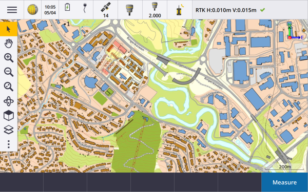
Map enhancements
In Trimble Access 2019.00, the ![]() icon replaces the
icon replaces the ![]() icon on the Map toolbar and the Video toolbar. Tap
icon on the Map toolbar and the Video toolbar. Tap ![]() to access map options including settings, scans, and filter settings. In the Video screen, tap
to access map options including settings, scans, and filter settings. In the Video screen, tap ![]() to access settings, snapshot options and filter settings.
to access settings, snapshot options and filter settings.
Pan to point and Pan to here are now available from the ![]() button in the Map toolbar. Pan to here is a useful shortcut to center the map at your current location in the map. For more options, such as to change the scale at which to zoom, select Pan to point and configure your settings and then tap the Here softkey in the Pan to point screen.
button in the Map toolbar. Pan to here is a useful shortcut to center the map at your current location in the map. For more options, such as to change the scale at which to zoom, select Pan to point and configure your settings and then tap the Here softkey in the Pan to point screen.
The Options screen previously available from the Active map screen in previous versions has been removed, and the Monochrome setting and the Explode polylines, DXF null elevation and Create nodes settings for DXF, Shape and LandXML files are now in the map Settings screen. To configure these settings, tap ![]() and select Settings.
and select Settings.
Displaying DTMs in the cross section view
When staking an alignment where the Display cut/fill to option is set to DTM or Design + DTM, the selected DTM is now displayed in the cross section view. It is displayed at your current position as a green line and includes a circle on the DTM indicating your position projected vertically to the surface.
Vertical distance calculator function
The Calculator now provides a V. Dist softkey. Tap V. Dist to calculate the vertical distance between two points. Tap Accept to copy the calculated value to the calculator for use in other calculations.
Refresh button in Projects and Jobs screens
The Refresh button ![]() is now always available in the Projects and Jobs screens. Previously the Refresh button was only available when you were signed in to Trimble Connect. Tap
is now always available in the Projects and Jobs screens. Previously the Refresh button was only available when you were signed in to Trimble Connect. Tap ![]() to see new projects or jobs, for example projects or jobs recently shared with you in Trimble Connect or if you have used File Explorer to copy a project or job into the Projects folder on the controller.
to see new projects or jobs, for example projects or jobs recently shared with you in Trimble Connect or if you have used File Explorer to copy a project or job into the Projects folder on the controller.
Reviewing attributes in Review job
When reviewing a point that has attributes in the Review job screen you can now view the attribute fields and their values without having to tap Edit. To change attribute values, tap Edit and then tap Attrib.
Changes when working with SX10 scan points
Trimble Access 2019.00 includes the following changes to handling points from scan files created using a Trimble SX10 scanning total station:
- You can now review points from a scan file without them being immediately copied into the job. Now, points from a scan file are copied only when you select them for a Cogo operation. This is consistent with the way Trimble Access works with points from CSV files.
- When selecting points from a scan file for stakeout or review, the software now limits the number of scan points that can be selected to a maximum of 20 points at a time. This means the software no longer allows you to select SX10 scan points for stakeout or review by dragging a box around them. To select fewer than 20 scan points, tap the individual points in the map.
SX10 Wi-Fi channel selection
You can now select the Wi-Fi channel to use for communicating with the Trimble SX10 scanning total station. This may be useful in congested Wi-Fi environments. To set the Wi-Fi channel the controller must be connected to an SX10 that has firmware S2.2.x or later installed. Tap ![]() and select Instrument / Instrument settings. Tap Wi-Fi and select the required channel.
and select Instrument / Instrument settings. Tap Wi-Fi and select the required channel.
Traversing sequence limit extended to 200 stations
You can now have up to 200 hanging stations in a traverse. In previous versions if you exceeded 50 hanging stations they were not coordinated.
GDM data and pseudo NMEA output
Trimble Access can now output measurement data to another device such as an echo sounder or a computer running third-party software when connected to any supported conventional instrument. Previous versions of Trimble Access supported outputting measurement data only when connected to a Trimble VX or S Series instrument.
Trimble VX and S Series instruments can output data through the foot connector, so you can output measurement data from the instrument or the controller. For other instruments you must connect the controller to the instrument and connect the device to the controller to output data from the controller to the device.
For more information, see the topic Data output in the Trimble Access Help.
FOCUS 30/35 service information
When connected to a Spectra Geospatial FOCUS 30 or 35 total station, you can tap the Service softkey in the Instrument settings screen to view the due date of the next instrument service.
Measure topo methods in tracking mode
When measuring a topo point with tracking mode enabled, the Method field in the Measure topo form now lists all methods, instead of only the methods that support tracking mode.
Dual prism heights in status bar
When measuring a point with a dual-prism offset, the status bar now displays the two prism constants.
New BeiDou PRN support
The BeiDou constellation now transmits PRN numbers up to 63. Trimble Access now supports this when used with Trimble R series receiver firmware version 5.41 and later.
Switching jobs during a survey
When performing job operations on job files other than the current job, Trimble Access now checks if there is an active survey. If there is one, it will prompt you to end the survey before continuing.
GNSS emulator enhancements
Trimble Access version 2019.00 includes the following enhancements to the GNSS emulator:
- The Move rover here option is now available from the tap and hold menu in the map when entities in the map are selected. In previous versions, this option was only available if nothing was selected in the map.
- When you tap Accept in the GNSS Emulator form, the form closes and now shows the map, instead of returning to the About screen.
- The GNSS Emulator DOS window now automatically closes when you power down the receiver or close the software.
For more information, see the topic To simulate a connection to a GNSS receiver in the Trimble Access Help.
Geoid model selection enhancements
Trimble Access now uses either the geoid model name or the geoid model filename to locate the appropriate geoid model. When selecting a geoid model, the geoid model name is now shown alongside the geoid model filename. When creating a job from a JobXML file, the appropriate geoid model is now automatically found using the geoid model name written into the JobXML file.
Coordinate system database updates
- Added coordinate system zones and geoid model for Vietnam.
- Updated coordinate system references for Slovakia.
- Added county system CCSF-CS13 for San Francisco.
- Added Landgate Project Grids and Mainroads Project Grids for Western Australia.
- Updated the default geoid models for Norway, Spain, France and India.
Resolved issues
- Closing the job: We have resolved these issues in the Closing job screen:
- When you open the Closing job screen the first option in the list is now selected so that when you tap Accept the software performs the selected action. Previously no options were selected which meant that tapping Accept did nothing.
- If you select Close All in the Closing job screen when a scan is in progress, the software now automatically stops the scan and saves it to the current job.
- Keypad: We have resolved these issues when pressing keys on the controller keypad:
- Using a combination of the SHIFT and CTRL keys on the TSC7 did not always work.
- If you configured a function key to open the Help, when you pressed the function key the software sometimes switched to a different Trimble Access application.
- Pressing the spacebar when in the Active map screen to select a layer now works correctly.
- Pressing the left arrow key when focused on a drop-down list field did not always change the value displayed in the field.
- Pressing the up and down arrow keys when focused on the Code list field did not always move the selection up or down the list.
- Map: We have resolved these issues in the map, where:
- When the height units for the job were changed the elevation values for points were not updated in the map.
- When tapping and holding the Zoom extents button on the map toolbar and selecting Zoom previous, or using the keypad shortcut Ctrl + Z, the map did not always return to the previous view.
If the map is empty and you layer on a map file, the map now automatically zooms to display the map entities in the file.
- The map did not always show active DXF, LandXML or Shapefile map layers in grayscale when the Monochrome check box was selected in the layers Options screen.
- The orbit point icon was not being displayed when rotating an IFC model.
- If you add both an IFC file and a TTM file to the map using the Layers screen, both files are now shown in the map as expected. Previously the TTM file was only shown in Plan view.
- We have restored the Reverse line direction item to the available options when you tap and hold a line in a linked map file, such as a DXF. This item was inadvertently removed from Trimble Access version 2018.20.
- The map was not always completely drawn when opening a job.
- When reopening a job, the software now opens the map showing the last used view for the job.
- DXF files: We have resolved several issues with DXF files, where:
- When you review a polyline in a DXF file that consists of a single element defining a line or an arc you can now see the details that define the polyline, including the start and end point details and slope distance.
- Trimble Access no longer displays DXF entities that have the _ModelSpace flag set to not be in the model space. Showing these entities could cause the map to have very large extents.
- Rotated OCS (Object Coordinate System) defined arc entities in DXF files are now displayed correctly.
- LandXML files: We have resolved the following issues with surfaces in LandXML files, where:
- Selecting the options to turn off the colour gradient or to display triangles for the surface did not work as expected.
- The map sometimes showed surface triangles in LandXML files that had been flagged as "invisible" in the XML file.
- Map display when using Cogo: We have improved the software behavior when zooming and panning in the map during Cogo computations.
- Measure to surface: We have resolved the following issues when measuring to a surface:
- From the Measure to surface form, if you returned to the Active map screen and turned off the current surface so that it was no longer visible, the current Distance to surface was saved and could then be stored and associated with new horizontal coordinates. Now, if you hide the current surface the Distance to surface field shows null (?) and measurements cannot be stored.
- In a conventional survey with tracking mode enabled, the cogo in‑progress line work now points to the closest point on the surface instead of sometimes pointing to the previous point.
- In a GNSS survey with the Tilt auto measure setting enabled, you can now measure to the surface without the software warning a measurement is already in progress.
- When measuring a compensated point to the surface, the Measure to surface details are now stored with the point.
- Improved performance when using very large surfaces.
- Points lists: When viewing lists of points, for example when reviewing points in the map or in the stakeout points list, points are now listed in chronological order. Tap the Name or Code header to sort by point name or code.
- Stakeout list cleared when changing selections in the map: You can now change selections in the map without affecting the current list of stakeout points, as long as the Stake out point list is not open. Close the Stakeout screen or make sure the stake out point navigation screen is visible to work in the map without changing the Stake out point list.
- Staking the start or end station of a line When you select the start or end station of the line to stake from the menu in the Station field, the Station field now updates to display the correct station value. Previously it would stake the start or end station selected, but the correct stationing was not always displayed in the Station field.
- Staking an alignment: We have resolved an issue when staking an alignment, where a template was inadvertently displayed in the cross section view and the V.dist value was reported to the template and not the alignment. This was an issue only when staking alignments that included templates (ie. a Trimble road) and the alignment was selected from the map.
- Fast fix: We have resolved an issue where tapping the Fast fix softkey when using some Cogo functions did not automatically populate the Point name field with the name of the newly measured point.
- On-screen keyboard in Area calculations: We have resolved an issue where if you use the on-screen keyboard to enter the Name in the Area calculation screen and then closed the keyboard, an imprint of the keyboard remained on screen.
- Duplicate distance offsets: We have resolved an issue when measuring a topo point with a distance offset, where after using Measure codes, duplicate distance offsets were stored for different horizontal angles.
- Code value for Station elevation points: When keying in a point during a station elevation, the Code field now correctly shows the code of the current point.
- SX10 scan in progress sometimes lost when changing jobs: We have resolved an issue where if you changed jobs while a scan was in progress and the level of the SX10 had changed during the scan, then despite choosing to save the scan in progress the scan data was not saved.
- SX10 stakeout navigation: We have resolved an issue where when connected to a Trimble SX10 scanning total station with tracking mode on, if you tapped Esc to exit the Stakeout screen then the software sometimes stopped providing navigation guidance when you returned to the Stakeout screen.
- Point overlay after updating station elevation with an SX10: We have resolved an issue when connected to a Trimble SX10 scanning total station, where if you updated the station elevation measurement then points overlaid in the video feed or the total station ray in the 3D map did not update to the new position. This issue affected the display of points only; the points were shown in the correct position if you used the Turn to or Stakeout functions.
- Use last station setup: We have resolved an issue where Trimble Access sometimes assigned the incorrect point type when copying the station setup from another job. The unexpected point type caused an issue on import into Trimble Business Center.
-
Station setup: We have resolved an issue when completing a station setup with Auto F1/F2 enabled, where measuring the F2 backsight and then abandoning the measurement and choosing to continue with the F1 backsight point only could result in an incorrectly oriented station setup.
- Station setup plus: We have resolved an issue where if you canceled a new station setup plus before making any observations you could no longer use the last completed station setup.
- Face 1 and Face 2 observations: We have resolved an issue where the software did not always check that the F1 and F2 observations to the point are within the preset tolerance.
- Tracking mode fields incorrectly displayed: The software no longer shows fields and settings related to tracking mode when the connected instrument does not support tracking mode (for example a Trimble C3 or C5 total station).
- PPM not being calculated: We have resolved an issue where the PPM was not being calculated when you changed the values in the Pressure or Temperature fields in the Atmosphere form in Review job.
- AT360 target ID: We have resolved an issue when working with multiple targets where it was possible to switch to the AT360 target in Trimble Access but the software was attempting to track the target using an incorrect target ID.
- GNSS rover antenna height not being read when starting survey in base mode: We have resolved an issue when starting a rover survey while in base mode where the software would not read the rover antenna height from the survey style after connecting to the rover receiver.
- RTCM transformation file error message: We have resolved an issue where special reserved Windows operator characters in RTCM transformation messages caused the message "The residual grid values could not be appended to the transformation file" to appear. These characters are now replaced with an underscore character and added to the .rtd file.
- Integrated survey resection does not prompt to use GNSS: We have resolved an issue where during a resection in an integrated survey, if you attempted to measure to a new point, the software warned that the point does not exist but did not offer to switch to GNSS so that the point could be measured.
- Locating prism in an integrated survey: We have resolved an issue where GPS Search would fail to find the prism if a large Prism to antenna offset was entered.
- Distance offset measurements with zero offsets: Distance offset measurements that have offset values of zero are now stored with the appropriate standard errors. Previously, they were stored like an offset measurement without any associated standard errors.
- Project location coordinate fields: We have resolved an issue where changing the Project location Entry method from Local coordinates to Grid coordinates did not cause the coordinate fields to change from Latitude, Longitude, Height to Northing, Easting, Elevation (and vice versa). The Project location fields are available when the Coordinates field is set to Ground (calculated scale factor) or Ground (keyed in scale factor).
- Project location grid coordinate values: We have resolved an issue where the Project location coordinate fields sometimes changed slightly after entry. This occurred only when Ground (calculated scale factor) was selected in the Coordinates field.
- Filtering the feature code list: When filtering the Code list to search for the feature code to select, you can now enable the Match function separately for codes and for descriptions. Searching by Code still automatically selects the first item found in the Code list. Tap or press Enter to add the selected code to the Code field for the current point. Searching by Description no longer automatically selects the first item found in the Code list. Tap an item or use the arrow key to select it and then tap or press Enter to add the code to the Code field for the current point.
-
Multiple codes in Code field in Measure points: We have resolved an issue where if you tapped the arrow next to the Code field and selected a new code after storing a point that was measured with two or more codes in the Code field, the new code was appended to the existing code string instead of replacing it.
- Empty attribute strings stored in job: We have resolved an issue where if you used the left arrow to select a different attribute value for a menu‑type attribute, the software stored an empty string in the job file.
- Export formats now output UTF-8 strings: The CSV WGS-84 lat longs, CSV with attributes, and Grid (local) coordinates export formats are now set to output UTF-8 strings. This matches the encoding setting for importing CSV files, which were already set to UTF-8. In previous versions of Trimble Access, these export file formats were set to output ISO-8859-1 strings. To change the encoding to a different format, edit the appropriate IXL and/or XSL file. For more information, refer to the Creating Custom Import Definitions PDF available from the Trimble Access Downloads.
- Export file error reporting: A useful error message now appears when you try to export to a non-existent folder or to a folder for which you do not have the appropriate write permissions.
- GNSS emulator not working: Trimble Access can now "connect" to the GNSS emulator reliably if you had started Trimble Access when the GNSS emulator was already running.
- Application errors: We have fixed several issues that caused application errors when using or closing the software. In particular:
- The software now allows you to deselect the feature library when creating a new job using the last used job as a template when the feature code list is still open in the software.
- When measuring points with feature codes, using the Start Circle (edge) code to add a line to a circle, and then deleting the line no longer results in an application error.
- The software no longer shows an application error when you "undelete" points in the Point manager.
- The software no longer shows an application error on opening the Point manager when data is being sorted by the Target height column.
- The software no longer sometimes shows an application error when you attach an image to a point in the Media file screen.
- The software no longer freezes when attempting to perform a Cogo transformation of a large number of points.
- The software no longer occasionally shows an application error when you end a GNSS survey while the software is changing to a new base station.
- The application no longer stops working correctly when you press a function key while turning a Focus 30 or 35 instrument using the on–screen joystick.
- The software no longer shows an application error when you start stakeout when connected to a conventional instrument that has Trimble VISION technology and you then start a GNSS survey or an integrated survey with GNSS as the current sensor.
Occasionally an issue pairing with a Bluetooth device would cause an application error if the device pairing produced an invalid Bluetooth address. Trimble Access now filters out devices with invalid addresses and does not display them for selection in the Bluetooth screen. You can resolve this issue by removing the device and re-pairing.
