2021.20
Version 2021.20 of the Trimble Access software is available from November 2021.
These Release Notes describe the new features and changes available in this release of the
New hardware support
Spectra Geospatial FOCUS 50 total station
Trimble Access version 2021.20 supports the new Spectra Geospatial FOCUS 50 total station.
Trimble EDB10 Data Bridge
Trimble Access version 2021.20 supports the new Trimble EDB10 Data Bridge.
When combined with an EM120 radio module, the EBD10 can be used with a controller that does not have an EMPOWER module bay, such as the TDC600 handheld, to connect and communicate with a Trimble robotic total station.
New features
Select files and folders from a Connect project for download
In Trimble Access you can now browse files and folders published to a Trimble Connect project and select them for download. The selected cloud folders and files are downloaded to the Trimble Access project directory. This makes it easy to retain the same file and folder structure across your organization's network, Trimble Connect, and Trimble Access.
On project refresh, Trimble Access will identify if there have been any updates in the cloud to the selected files and folders which need subsequent download. The download screen allows the pre-selected files to be skipped if they are not required at that time.
Jobs can be created in Trimble Access. Job files synchronized to the cloud are shown in Trimble Sync Manager as usual.
For more information, see the topic Managing projects in the Trimble Access Help.
Sharing projects and jobs with other people
You can now share cloud projects and jobs with other people from within Trimble Access.
To invite people to the project, and manage who is in the project team, select the project in the Projects screen and then tap ![]() and select the Team
and select the Team ![]() tab.
tab.
To assign the job to someone in the project team, open the job and then in the job details pane, tap  . In the Assignees list, select the team member or members to assign to the job and then tap Accept. Upload your changes to the job to the cloud. To assign a job to someone, the job must reside in the cloud.
For more information, see the topic Managing team members in the Trimble Access Help.
SX10 and SX12 support on Android controllers
You can now use the TSC5 controller and the TDC600 model 2 handheld with the Trimble SX10 or SX12 scanning total station. You can use the scanning total stations to complete regular survey work as well as scan and view point clouds (.rcwx files). IFC and TrimBIM models are not currently supported on Android controllers.
Connections to the SX10 or SX12 are not supported when using the TCU5 controller or the TDC600 model 1 handheld. Connections to older SX10 scanning total stations with a serial number less than 30415001 are not supported with any Android controller.
New scan frame methods for SX10 and SX12 scanning
When scanning using a Trimble SX10 or SX12 scanning total station, Trimble Access provides two additional scan frame methods:
-
Select Half dome to scan 180° horizontally (centered at the HA of the instrument), and vertically up to the zenith and down to 148° (164 gon).
-
Select Rectangle - sides and then tap in the video window to define the left side and then the right side of the scan frame. By default the vertical edges of the rectangle are up to the zenith and down to 148° (164 gon), but you can limit this if required.
To incorporate the new scan frame methods we have renamed the existing Rectangle frame method to Rectangle - corners.
For more information, see the topic To scan using an SX10 or SX12 in the Trimble Access Help.
Object oriented station setup
You can now perform an Object oriented setup to set up the total station in the coordinate system of an object of interest, where the Z axis of the object is not aligned with the vertical axis of the instrument. This setup can be used in a variety of situations, for example:
-
In a manufacturing environment where the object of interest, such as a beam or concrete slab, is not sitting flat.
-
On a moving platform such as a barge or an oil rig where the instrument cannot be leveled.
The object oriented station setup is available only when the Object Oriented Setup Trimble Access software option is licensed to the controller. To purchase a license for the Object Oriented Setup option, contact your Trimble Distributor.
You can complete an object oriented station setup using one of these methods:
-
Known points: There must be at least three points in the job that are in the same coordinate system as the object. These points may be points in a design file such as an IFC or DXF file, or in a linked CSV file. You will select and measure to these points during the station setup.
-
Point, edge, plane: The job must contain design files that contain a point, edge, and plane. You will select and measure to these entities during the station setup.
The measurements to the three known points or known entities (point, edge, plane) are used to orient the instrument to the object during the station setup. Subsequent measurements will then be correctly oriented to the object. The software calculates a least-squares algorithm to determine coordinates for unknown points.
All object oriented station setup observations must be on face 1.
For more information, see the topic To complete an object oriented station setup in the Trimble Access Help.
LAS point cloud export format
You can now export scan point clouds and regions created using a Trimble SX10 or SX12 scanning total station to the LAS file format version 1.4.
During export, only the scan point clouds and regions that are currently displayed in the map are exported. To include or exclude some regions or point clouds, select or deselect scans or regions in the Scans tab of the Layer manager. Point clouds are exported in the same coordinate system as the current job.
The LAS point cloud export option is available only when the Trimble Access software LAS Export option is licensed to the controller. To purchase a license for the LAS Export option, contact your Trimble Distributor.
Augmented reality viewer
Trimble Access version 2021.20 features the new Augmented reality viewer, for use during an RTK survey using a Trimble GNSS receiver with IMU tilt compensation. The Augmented reality viewer shows map data in 3D, overlaid on the view from the controller camera, enabling you to interact with your spatial data in the context of the real world. Position and orientation information is provided by the connected GNSS receiver.
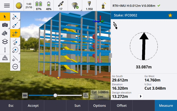
Use Augmented reality viewer to:
- Visualize map data in 3D, overlaid on the view from the controller camera.
- Use for guidance before beginning precise stakeout.
- Capture images that show the site as well as the features overlaid on the site.
- Document important visual information and share it with stakeholders.
With the exception of background image files, all map files supported in Trimble Access and job data are shown in the Augmented reality viewer. You can use any map tools, including the Layer manager, Limit box, Snap-to toolbar, and CAD toolbar to work with the data shown.
Augmented reality viewer is available only when you are running Trimble Access on a Trimble TSC7, TSC5, or TDC600 controller and you have started a survey using a Trimble GNSS receiver with IMU tilt compensation.
For more information, see the topic Augmented reality viewer in the Trimble Access Help.
12da file support
Trimble Access General Survey and Roads now support the display of 12da files in the map.
12da files can contain point, line, arc, circle and polyline strings that are read and treated as standard point line, arc and polyline entities in General Survey. They can also contain super alignments and alignments that have horizontal and vertical definitions that are read and treated as alignments in General Survey and Roads. There is also support for triangulated surfaces.
For more information, see the topic 12da files in the Trimble Access Help.
TXL file support
Trimble Access General Survey and Tunnels now support the display of tunnel (.txl) files in the map, where they can be visualized in 3D and used to perform surface inspections comparing the TXL and SX12 scan data.
TXL files typically contain a horizontal and vertical alignment along with templates that define the shape of the tunnel. TXL files can be created in Trimble Business Center or by keying in the definition using Trimble Access Tunnels.
Previously, TXL files could only be viewed in the Tunnels plan view or cross section view.
For more information, see the topic TXL files in the Trimble Access Help.
Enhancements
Sign in button
The Sign in button in the Projects screen and the Jobs screen now has a user icon rather than a Trimble Connect icon. Tap the Sign in ![]() icon to sign in. Once you are signed in the Sign in icon changes to yellow
icon to sign in. Once you are signed in the Sign in icon changes to yellow ![]() .
.
Cloud icons on the Projects and Jobs screens are now buttons
The cloud icons next to the project or job name that indicate if there are changes to be downloaded to the controller or uploaded to the cloud are now buttons that you can tap to take action:
-
Tap
 to download all modified files in the project or job.
 -
Tap
 to upload all modified files in the project or job.
 -
Tap
 and select Upload to decide whether to upload or download files.
 -
Tap
 and select Upload or Download to view which files on the controller are in conflict with those in the cloud and to take appropriate action.
For more information, see the topic Synchronizing data with the cloud in the Trimble Access Help.
Managing file conflicts
When downloading files to the controller or uploading files to the cloud, if a conflict between changes made to the file in the cloud or to the file on the controller are detected, Trimble Access now automatically shows a pop‑up menu next to the name of the file in conflict. The pop-up menu provides choices to overwrite the local file or to keep the local file. In previous versions, the pop‑up menu was only shown by tapping and holding on the file in conflict.
Restricted job visibility for users
For cloud projects the Restrict job visibility setting is now disabled by default. This means that anyone assigned to the project can download and view the jobs in the project but they can only work on those jobs if they are assigned to them.
The Restrict job visibility check box is only shown (and can only be changed) if the signed in user is assigned the Administrator role.
If Restrict job visibility is enabled, users with the User role will never see jobs that are not assigned to them.
Because Trimble Access prevents users from working on jobs that are not assigned to them, always make sure users are assigned to the jobs they need to work on. If a Trimble Access user is unable to see a job or is unable to make changes to a read-only job, assign them to the job. Do not attempt to create an editable copy of the job on the controller, for example by copying the job from a USB drive or by downloading it from an email. Creating a copy of the job can cause unintended problems when you attempt to upload the data to the cloud, such as duplicate jobs or lost data.
Jobs always remain visible to project administrators, the person who created the job, and users who are assigned to the job, irrespective of whether the Restrict job visibility setting is enabled or disabled.
Alignment stakeout enhancements
The alignment stakeout workflows have undergone some significant improvements by combining the traditional menu workflow with the map based workflow. You can now see the map during alignment stakeout and interact directly in the map to select the alignment and station to stake.
To stake alignments, select the alignment in the map and tap Stakeout. To stake:
-
To the alignment, tap Start. This is the default stake method.
-
A Station on alignment, tap a station and then tap Start.
-
A Skew offset, select the Skew offset method from the Stake field and use the Station and Skew offset softkeys to set the station and offset.
-
A Side slope from alignment, select the Side slope from alignment method from the Stake field and use the Station and Side slope softkeys to set the station and side slope.
We recommend you explore the new alignment stakeout workflows before upgrading field crews and sending them to the field. Stay tuned for further improvements in the next release.
-
Tap in the map to clear the current selection and set the stake method To the alignment. Tap a station to select a station and set the method to Station on alignment.
-
Construction offsets can be defined from the tap and hold menu in the map.
Stake sideslope from polyline
When staking a sideslope from a polyline you can now stake the hinge position as well as the cut slope hinge position if the side slope definition includes a cut ditch. The hinge position and the cut slope hinge position are displayed in the map and can be selected and staked.
Stake elevation
When staking an elevation you can now tap a point in the map to set the Design elevation to stake.
Stakeout delta horizontal distance to end of line
When staking a line, arc, polyline or road, or when staking a point on a line, arc, polyline or road, you can now choose to view the H.Dist to end stakeout delta. The H.Dist to end delta is the 2D or horizontal distance from the current location projected to the end of the line, arc, polyline, or road.
Stakeout delta "Code"
When selecting stakeout deltas you can now select Code to display the Code of the entity being staked in the Stakeout screen.
For more information, see the topic Stakeout navigation deltas in the Trimble Access Help.
Save stakeout delta preferences
When selecting stakeout deltas, you can now tap the Save to style softkey to save your changes to the current survey style.
Stake out point in Video screen
When staking out a point, the point being staked is now shown in the Video screen using the same stakeout target icon as shown in the map.
Feature coded linework treated as polylines
Where there are more than 2 points in a sequence before the line is stopped or a control code is used to skip or join to another code, feature coded linework now creates a continuous line segment or polyline. The linework is not saved to the job as a polyline, but created on-the-fly from coded points. The polyline can be selected and staked. Or, to select an individual section of the polyline, tap and hold on the individual section of interest and then from the tap and hold menu select Select feature coded line segment.
Compute average enhancements
We have made these improvements to the Compute average cogo function:
-
When you select points from the map and then select Compute average, the Map selected points method is now automatically selected.
-
If you select a single point in the map and there are multiple observations to it, then you can select Compute average from the tap and hold menu to average the observations.
Controller camera softkey in Project properties screen
The Project properties screen now has a camera softkey. When creating or editing a project, tap  to capture a photo using the controller camera. The captured image is automatically selected as the project image.
Layer manager enhancements
We have made some minor changes to the Layer manager to improve the display of information. These include:
-
Column widths are now remembered.
-
The Type column now appears next to the Name column in the Map files and the Point files tabs.
-
The file extension is no longer shown as part of the file name in the Map files tab.
-
The Inspections tab no longer appears on Android devices, as surface inspections are not supported when running Trimble Access on an Android device.
Opacity setting renamed to Transparency
The Opacity setting in the Map settings screen
Transparency slider control in SX Video screen
When the connected instrument is a Trimble SX10 or SX12 scanning total station, the Video screen now displays the Transparency slider control.
Use the Transparency slider control to control the transparency of the Video feed and IFC files and point cloud data in the Video screen.
Drag the slider to the left to make map data more transparent, or drag the slider to the right to make the Video feed more transparent.
Points, lines, arcs, and polylines and feature labels remain full intensity, regardless of the Transparency slider setting.
Android 64 bit
Trimble Access is now installed as a 64 bit application for Android on the TSC5 and TDC600 64 bit controllers. 64 bit applications can manage larger map files better.
Vertical offsets for GNSS continuous topo points
In a GNSS survey, you can now add a vertical offset calculated from measured points. To add a vertical offset, tap Options. Select the Add vertical offset check box and then in the Measure points or Continuous topo screen enter a value in the Vertical offset field. Vertical offsets are not supported for observed control points.
Auto-connect to GNSS receiver
For improved connection reliability, auto-connect to a GNSS receiver is now automatically disabled for all controllers when the software connects to any conventional instrument. Auto-connect is automatically re-enabled when the connection to the instrument ends, or when an integrated survey is started.
GNSS RTK NTRIP mountpoint selection
The NTRIP mountpoint table now shows coordinate system information for each mountpoint, if that information is available, so that you can more easily select a mountpoint that uses the same coordinate system as the job. Tap a row in the table to view more detailed information for the selected mountpoint.
There are also more options for sorting the list of mountpoints. Tap the sort field above the list and choose to sort by Distance, Format, or Mountpoint.
Site calibration enhancements
We have made the following changes for site calibrations:
-
When you tap Accept in the Site calibration screen of the survey style, the site calibration settings are now written to the job database. The settings stored in the job database are used if you return to the site calibration function, for example to add new points to the site calibration computation.
In previous versions of Trimble Access, the settings from the current survey style were used in all site calibration computations, not the settings from the current job. To restore the settings from the current survey style, use the new Default softkey in the site calibration Options screen.
As with previous versions of the Trimble Access software, you can change the site calibration settings any time.
-
We have changed the default site calibration settings. By default Constant adjustment only is now selected in the Vertical adjustment field.
-
The Site calibration screen of the survey style now provides a Fix horizontal rotation to zero check box to control whether the calibration calculation should fix or compute the horizontal rotation. This check box is not selected by default.
Selecting the Fix horizontal scale to 1.0, Fix horizontal rotation to zero, and Constant adjustment only options is recommended if you are working in a modern well-defined coordinate system with a reliable transformation from the global reference frame and you are using a high quality local control within that coordinate system as well as an accurate geoid model.
For more information, see the topic To configure the survey style for a site calibration in the Trimble Access Help.
T04 GNSS data files
When logging raw GNSS data to the receiver during a survey, for receivers with firmware version 5.46 or later the data is now saved to a T04 file instead of a T02 file.
GNSS eBubble size
The GNSS eBubble pop-up window now resizes automatically on all controllers, resulting in a slightly larger GNSS eBubble than previously on the TSC5 controller.
We have removed the Size field from the eBubble options screen.
Set coordinate order to match CAD files
You can now set the Coordinate order for the job to XYZ (CAD), so that the coordinates are in the same order as CAD files.
The existing Y‑X‑Z and X‑Y‑Z coordinate orders follow the geodetic convention that Y is the East axis and X is the North axis, forming a left-hand coordinate system. The new XYZ(CAD) coordinate order follows the mathematical convention and forms a right-hand coordinate system. You can configure the Coordinate order for the job from the Job properties screen.
For more information, see the topic Units in the Trimble Access Help.
Set job units to millimeters
You can now set the distance units for the job to millimeters. This is especially useful when working with design files for use in a manufacturing environment. Configure job units from the Job properties screen. When using millimeters, you can set the Distance display field to display distance/length values as whole numbers or to one decimal place.
Sound events now available in Lithuanian
When Lithuanian is selected in the Select language screen of the Trimble Access software, voice messages such as Observation stored are now provided in Lithuanian instead of English. To be able to select Lithuanian as the language, you must install the Lithuanian language and help files using Trimble Installation Manager.
Coordinate system database updates
The coordinate system database installed with Trimble Access includes the following enhancements:
-
Updated Geoid Model for Romania to ROvT4.06
-
Updated Russian GSK-2011 (GOST 32453-2017) datum parameters
-
Updated Geoid for Japan GSIGEO2011 (Ver.2.1)
-
Added NTV2 Grid Transformation ETRS89 to MGI for Austria
-
Added Singapore Geoid Model 2009 (SGEOID09)
-
Added Kinematic Datum SIRGAS-Chile 2016
-
Added Kinematic Datum SIRGAS-AG = SIRGAS-CON at epoch 2016
-
Improved management of ETRS89 in Czech Republic & Poland
Resolved issues
-
Downloading projects: If the project information is not up to date when starting a download Trimble Access now automatically refreshes the project information before starting the download.
-
Downloading report stylesheets: We have fixed an issue when downloading projects to the controller, where report stylesheet files attached to the project were not always downloaded.
-
Job status: We have fixed an issue where if you changed the status of a job in the cloud, or if you changed the status of a local job and then uploaded it to the cloud, the new status was not shown and you had to update the status again.
-
Job templates: The default Station display for the US Survey Feet Scale Only and the International Feet Scale Only templates is now 10+00.0. Previously it was 1+000.0 m.
-
Coordinate systems: We have fixed an issue where the Global reference frame and Global reference datum were not always shown if the coordinate system included a datum shift grid.
-
Grid coordinates: We have fixed an issue when keying in grid coordinates for a project location, where the units were always set to meters, even if the job units were set to feet. The units for keying in the grid coordinates now use the units set for the job.
-
Default datum transformation: Jobs containing a projection but no datum transformation are now given a zero three parameter datum transformation. This includes new jobs (including those created from DC or JXL files) and jobs that are upgraded from earlier versions. Assigning a default datum transformation avoids issues where stakeout line would give incorrect stakeout deltas when there was a projection in the job but no datum transformation.
-
Favorites: We have fixed an issue where software functions for some Trimble Access apps that you had added to your Favorites list or assigned to function keys were not remembered if you restarted the software.
-
Layer manager: Visibility and/or selectability changes for Map files are now remembered if you switch to a different tab before tapping Accept. This was an issue only if Auto update was not selected.
-
Snap-to toolbar: When you tap a tool in the Snap-to toolbar, the map now automatically switches to Select mode, ready for you to select the line, polyline or arc to snap to in the map. Previously the map remained in the current mode, for example Pan or Zoom.
-
Station values in the map: If the display of station values is enabled in the Map settings, station values for a line, polyline, or arc are no longer displayed if you set the line, polyline, or arc to not visible using the Layer manager.
-
Map labels on Android: We have fixed an issue where labels disappeared when zooming and panning the map on an Android device.
-
Limit box: We have improved the performance of the Limit box when using point clouds.
-
Nodes: We have fixed an issue where nodes were not always displayed in the map after the None softkey in the Layer manager was used.
-
Surface inspection color scale: We have fixed an issue where if you created a surface inspection color scale with values that did not straddle 0.0, then the color bar was not drawn correctly.
-
Surface inspection messages: We have improved the text of surface inspection messages to give better guidance on how to remedy issues that may occur when using the surface inspection feature.
-
Point clouds in the Video screen: When point clouds are active, as well as map points and BIM files, point clouds now appear on top of BIM files in the Video screen, but under map points.
-
Point cloud updates: We have fixed an issue where point clouds were not updating when you edited the Instrument height or Target height in the Review job screen.
-
LandXML files: We have fixed a number of issues with LandXML files:
-
Selected map entities in different LandXML files now have unique names.
-
If a LandXML file contains an arc that starts and ends at the same point (forming a circle) then the circle is now displayed in the map.
-
If a LandXML file from Autodesk Civil 3D software contains an invalid <Curve> element, the <Curve> element is no longer displayed. Previously, the center point of the curve was incorrectly used as the coordinates of the midpoint of the curve (arc), and the arc was incorrectly displayed.
-
-
Import CSV: We have fixed an issue where a previously entered note record was appended to imported points.
-
Attribute images: We have fixed an issue when linking an image to an attribute, where the last image linked to the job was used rather than the last captured image.
-
Last used attributes: Setting the default attribute values to Last used now reliably populates the attributes fields with the values from the last measured point when measuring a point or topo point.
-
Stakeout performance: We have improved the performance of all forms of stakeout when DXF files are visible or active in the map. Sometimes the stakeout updates would lag behind the actual position of the antenna.
-
Stakeout line, arc or polyline: When staking a linear entity you can no longer change the direction during stakeout by tapping on the line in the map. Either set the direction before starting stakeout, or use the Reverse line direction option from the map tap and hold menu.
-
Stakeout polyline: We have fixed a number of issues when staking out a polyline. These included:
-
Occasional issues where you could not select some stations, or you could select stations that you should not have been able to, such as beyond the end station.
-
Issues where station values were sometimes either not shown correctly or were not being updated during stakeout.
-
Issues where delta values sometimes showed null or were incorrect.
-
Issues where temporary lines and symbols drawn on the map during stakeout were sometimes either not drawn correctly or were not being updated.
-
Station values were shown when the station interval was set to null (?). Now station values are shown for the start and end stations plus any PI, PC, or PT stations when the interval is set to 0, and shown for all stations when a station interval is set.
-
-
Staking polylines using projections with significant scaling and ground distances: We have fixed an issue when staking a polyline with arcs of a large radius in a job with significant scaling and ground distances. Arc calculations are now computed correctly regardless of the Distances setting.
- Stakeout line: We have fixed a number of issues when staking out a line. These included:
- Issues where the method selected from the tap and hold menu in the map was not respected in the stakeout form and so had to be reselected.
- Issues where temporary lines and symbols drawn on the map during stakeout were sometimes either not drawn correctly or were not being updated.
-
Staking out from IFC: We have fixed an occasional problem displaying the target symbol when staking from an IFC model.
-
Stakeout elevation: When staking an elevation, the Show stakeout graphics switch is now available in the Stakeout options screen.
-
Re-measure: We have fixed an issue when remeasuring a position (for example, after an "Excess movement" or "Position compromised" warning), where if you tapped the Re‑meas softkey the software incorrectly reported a measurement was already in progress and you were unable to continue without first restarting the survey.
-
GlobalFeatures.fxl: The GlobalFeatures.fxl feature library file installed with new installations of the Trimble Access software has been updated to remove unnecessary layers and to rename an attribute name. Previously the attribute label on the code SvyDisk included commas which caused an error if the file was used in Trimble Business Center.
-
Feature codes: We have fixed an issue where the previous code entered in the Measure topo or Measure points form was stored with the point instead of the code set using Measure codes.
-
Multiple feature codes: We have fixed an issue where a point had two codes requiring attributes and some of the attributes were not stored with the point.
-
DTM offset: We have fixed an issue where if you had set the offset method in the DTM field to a value other than <None> and then changed the selected offset method to Vertical or Perpendicular then the DTM field reverted to <None>.
-
Connections form Favorites: We have fixed an issue where if you assigned a favorite or function key to one of the tabs in the Connections form, the assignment was not saved.
-
SX video: We have improved performance when viewing the Video screen when connected to a Trimble SX10 or SX12 scanning total station.
- Instrument turning: We have fixed an issue where sometimes pressing the arrow keys on the keypad to turn the instrument did not work as expected when a form was open alongside the Video screen.
-
Measure rounds: We fixed an issue where the mean turned angles were not being calculated and stored. This was an issue only if, when measuring rounds, the process was interrupted before it was complete.
-
Station elevation: We have fixed an issue where points could not be selected from the map when performing a station elevation on multiple points.
-
Continuous topo with FOCUS 35: We have fixed an issue where Stop and go continuous topo using a FOCUS 35 did not work.
-
AT360 eBubble: We have fixed an issue where the eBubble would sometimes not appear when connected to an AT360 active target.
-
Recalculating station elevations: When you delete a point from a station elevation calculation, the corresponding observation is now also deleted. Previously, the original observation was kept which could result in different results when the point was recalculated in Trimble Business Center.
-
Observation stored incorrectly played: When measuring topo points in a conventional survey, the Observation stored sound is no longer played when you tap Esc in the Attributes form to discard attributes or when you tap Yes to confirm you wish to delete a point.
-
Import from receiver: You can now sort the files to be imported from the receiver by tapping any column header.
-
Base receiver Internet connection: We have fixed an issue where after ending a base survey the software sometimes warned that rovers were still connected to the base even though there were no longer any rovers connected.
-
R12i IMU bias calibration: If you change the screen orientation of the controller during the IMU bias calibration routine, the software no longer returns to the calibration start screen.
- Averaged observations on TSC5: The contents of the Averaged observations form are now shown correctly when you resize the form. Previously, making the form smaller obscured some information in the form.
- PDF reports on TSC5: You can now view PDF reports on a TSC5 controller. Previously the report would either fail to display or the fields would be empty.
-
Unable to accept EULA: We have fixed an issue when running the software for the first time on a controller with a very low battery, where you were unable to accept the EULA because the controller low battery warning had appeared in the background and required action.
-
Signing in to Trimble Access using Microsoft Edge: We have fixed an issue when attempting to sign in to Trimble Access using the Microsoft Edge browser where the sign in screen did not appear correctly and the browser reported an error.
-
Survey styles: The Options softkey has been removed as it served no useful purpose.
-
Application errors: We have fixed several issues that caused occasional application errors when using or closing the software. In particular:
-
When attempting to open a job that has a missing geoid file.
-
When you select a polyline to auto stake where the polyline consists of more than one a line.
-
When importing a file into a job where the file name is longer than 58 characters and then exporting from the same job as a dc file.
-
During stakeout when selecting items to stake out from the selected entities list.
-
If you tap the Stn+ softkey when staking the end station of a line.
-
If you close the software when the Select reference alignment form is open.
-
If you press an arrow key when viewing any screen that shows a tree folder structure when no node in the tree structure is selected.
-
After upgrading to a recent version of Trimble Access from version 2018.xx.
-
