2020.20
Version 2020.20 of the Trimble Access software was released in December 2020. To download these release notes as a PDF file, click this link.
These Release Notes describe the new features and changes available in this release of the Trimble® Access™ software.
New features
Upload projects created in Trimble Access to the cloud
You can now upload projects you have created locally on the controller to the cloud. Simply select the project in the Projects screen and then tap ![]() and select Upload. Once the project resides in the cloud you can select and upload any local jobs to the cloud from the Jobs screen.
and select Upload. Once the project resides in the cloud you can select and upload any local jobs to the cloud from the Jobs screen.
Projects and jobs that reside in the cloud can be easily shared with other team members or managed from the office using Trimble Sync Manager.
To be able to upload a project to the cloud the controller must be connected to the Internet and you must be signed in using your Trimble ID. If you do not have a Trimble ID, you can create one from the Sign in screen. To view the Sign in screen, tap the ![]() icon in the title bar of the Projects screen.
icon in the title bar of the Projects screen.
For more information, see the topic To upload a local project to the cloud in the Trimble Access Help.
Surface inspections
Use the new Surface inspection feature to compare an as-built surface, such as a horizontal floor, vertical wall, inclined plane, or cylinder, with a reference surface. The Surface inspection Cogo function calculates the distance to the reference surface for each point in the selected scan(s) and creates an inspection point cloud.
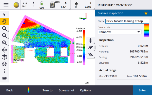
Points in the inspection point cloud are color-coded to provide immediate visual feedback between the point cloud and the reference surface. When inspecting a brick facade, for example, you will be able to see whether any sections of the facade are showing signs of movement off vertical.
Select any scan point to view information specific to that point. To turn the connected instrument to the selected point, tap Turn to.
Tap Store to save the inspection point cloud to the job. You can also save screen captures and annotate them if required, to highlight particular point details and problem areas.
Only scans created using a Trimble SX10 scanning total station can be used in the surface inspection. Multiple scans can be used if more than one scan is required to cover the as-built surface.
For more information, see the topic Surface inspection in the Trimble Access Help.
Repeating SX10 scans
If you are using a Trimble SX10 scanning total station to scan the same area multiple times, you can now quickly and easily repeat scans by loading the settings from a previous scan in the same job or a linked job. For example, you can scan a floor once to find the high or low areas that need leveling, and after performing remedial work you can repeat the scan to confirm the floor is within the required tolerances.
For more information, see the topic To repeat SX10 scans in the Trimble Access Help.
Enhancements
Changing the size of the map and form
You can now resize any form that appears alongside the map, on any controller. Previously, you were only able to do this when using a Trimble TDC600 controller.
In addition, the software now remembers your preferred size for different forms.
- When viewing the Trimble Access software in landscape mode, tap
 and swipe left or right to resize the form. In portrait mode, tap
  and swipe up or down to resize the form. The form resizes to the closest preset position.
 - To minimize the form temporarily to get a larger view of the map, tap and swipe to the very right of the screen, or tap and swipe down to the very bottom of the screen.
- To make any form full-screen, tap and swipe to the very left of the screen, or tap and swipe up to the very top of the screen.
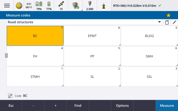
A larger form can be especially useful when using a feature like Measure codes, where you are interested in larger buttons and are not interested in seeing much of the map, or any map at all.
|
|
Favorites and Functions enhancements
Favorites and Functions enable you to create shortcuts to software screens, map controls, or to enable/disable an instrument or receiver function.
We have added these functions to the Assign special functions list:
- Toggle stakeout auto F1/F2
- Toggle measure auto F1/F2
- Switch satellite group
- Menu softkey
- Enter softkey
To assign a function key shortcut to a software function for which there is no ![]() icon, tap
icon, tap ![]() in the Favorites screen and tap + on the function key you want to use and select the function you want to assign.
in the Favorites screen and tap + on the function key you want to use and select the function you want to assign.
For more information, see the topic Favorite screens and functions in the Trimble Access Help.
F2 display is now available when connected via Bluetooth
When the controller is connected to a Trimble S Series total station using Bluetooth, the Face 2 (F2) display is now enabled.
This applies to all controllers including third‑party tablets, and is particularly useful when using a Trimble TDC600 controller attached to the instrument using the S Series Instrument Bracket (P/N: SSERIES-CB-10).
Password support for direct IP connections to Trimble base receivers
Trimble Access now supports passwords when connecting directly to a Trimble base receiver over the Internet for a GNSS RTK survey. Previously, passwords were supported only when connecting to an NTRIP server.
Coordinate system enhancements
Trimble RTX positions now transformed using local displacement models
Improvements have been made to the time-dependent coordinate transformation feature, which is used to transform Trimble RTX® positions between ITRF 2014 at the epoch of measurement and the global reference frame:
- Local displacement models are used when available.
- Where no local displacement model is available, Trimble Access uses ITRF tectonic plate velocities, rather than the MORVEL56 tectonic plate velocities that were used in earlier versions.
- Country-specific realizations of the ETRS are used in Europe.
These improvements ensure that users obtain optimal accuracy in coordinate transformations and the best possible coordinates in the selected coordinate system.
For a list of affected countries, refer to the following table:
| Country | Reference frame | Local displacement model |
|---|---|---|
| Australia | GDA2020 | None* |
| Brazil | SIRGAS2000 | VEMOS2009 |
| Canada | NAD83(CSRS)v7 | CSRS Velocity Grid V7.0 |
| Denmark | EUREF-DK94 | NKG-RF03 |
| Estonia | EST97 | NKG-RF03 |
| Finland | EUREF-FIN | NKG-RF03 |
| France | RGF93v2 | ITRF2014 |
| Germany | ETRS89-DR91(R16) | ITRF2014 |
| Iceland | ISN2016 | ISN2016 |
| New Zealand | NZGD2000 | NZGD2000 Deformation Model |
| Norway | EUREF89 | NKG-RF03 |
| Russia | PZ-90.11 | None |
| Sweden | SWEREF99 | NKG-RF03 |
| UK | OSNetv2009 | ITRF2014 |
| USA | NAD83(2011) | HTDP V3.2.9 |
* Australia does not use a displacement model, since the tectonic plate motion is captured in the published 14-parameter datum transformation.
To use Trimble Access 2020.20 jobs that use displacement models in Trimble Business Center, you must use Trimble Business Center version 5.40.
Older Trimble Access jobs with RTX data can be used in Trimble Access 2020.20. When you select the job the software will warn that the coordinates are different. You can choose whether to upgrade the job so that you can use it with the new displacement model. Note that the as-stored RTX coordinates do not change, just the transformation. If you choose not to upgrade the job you will only be able to use the job in a previous version of Trimble Access.
For more information, refer to the white paper Deformation models in Trimble Access 2020.20 and Trimble Business Center 5.40.
Trimble Access now automatically selects the Tectonic plate used for RTX surveys
When you start an RTX survey, Trimble Access now uses the local displacement model, or if no local model is available for your location, the software selects a tectonic plate in the global tectonic plate model, to propagate the ITRF 2014 coordinate from the epoch of measurement to the Global reference epoch for the job. Previously the software prompted you to select the tectonic plate to use.
The Tectonic plate field now appears in the Select coordinate system screen, rather than the Job properties screen. The Tectonic plate field appears only if the Displacement model is a global tectonic plate model (ITRF 2014).
Trimble Access now supports keying in an ITRF 2014 coordinate as X, Y, Z, and T coordinates
For any job you can now select ITRF 2014 from the Coordinate view field and key in ITRF coordinates (that you receive from a postprocessing service such as RTX, for example) as X, Y, Z, and T (time/epoch of measurement) coordinates.
Coordinate system database updates
- Added datums, geoid, and zones for Fehmarnbelt project in Denmark.
- Added datum EUREF-DK94 for Denmark.
- Added datum EUREF-FIN for Finland.
- Added datum ETRS89-DREF91(R16) for Germany.
- Added geoid model for Slovenia which is now referenced by the Slovene National Grid zone.
- Added datum JGD2011 for Japan and State Plane 2011 zones referencing this datum.
- The EGM 2008 geoid sub-grid is now referenced in all zones in Russia.
- The Geodetic Ref System 1967 ellipsoid semi-minor axis is now defined to only 3 decimal places, to conform with the definition used by Hungary.
- Modified the global reference datums for existing local datums:
- NAD 1983 (Canada): was NAD83(CSRS) now NAD83(CSRS)v7 (EPOCH:2010)
- Ordnance Survey: was ETRS89 now OSNetv2009
- PZ-90.11: was WGS1984 now PZ-90.11
- HS2 Survey Datum 2002: was ETRS89 now OSNetv2009
- HS2 Survey Datum 2015: was ETRS89 now OSNetv2009
- FEH2010 (from GPSnet.dk): was ETRS89 now EUREF-DK94
Resolved issues
- Projects screen: We have fixed an issue where the Projects screen was sometimes slow to respond, especially when there were a large number of projects and/or the projects had large image files attached.
- Downloading jobs: When attempting to download a job when you are not signed in to Trimble Connect, the software now displays the Sign in screen, rather than a message stating that project information could not be fetched from Trimble Connect.
- Point files in subfolders: The Point files tab in the Linked files screen now shows all CSV and TXT files in the current job folder as well as any nested folders up to the project folder. This now matches the behavior of the Map files tab.
- Duplicate points: When sorting lists of points by database order or by name, duplicate points now appear in indented groups so that they always stay together regardless of the sort direction. When sorting by any other criteria, such as code, duplicate points are not grouped together and all points are sorted independently of each other. In Point manager, any deleted point records now appear below the correct points in the list.
- DXF export: Smooth curves and three-point arcs created using feature coded linework are now exported correctly in DXF files.
- BIM models: We have improved the display and selection of entities in a BIM model for jobs where the Cogo settings / Grid coords option is set to Increase North-West or Increase South-East. Previously polyline or polyedge selections were not drawn in the correct position. Surface selections were drawn in the correct position, but when they were used in calculations the results of those calculations were positioned incorrectly.
- Selecting items in the map: When you select a line or arc in the map that is close to other features, prompting the software to display the entity selection list, the map no longer auto-zooms out to show the extents of the selected entity.
- Reviewing multiple entities: When you select multiple entities in the map and tap Review, the correct entity is now highlighted when you use the Next or Prev softkey to move between entities.
- Filtering linked file points: The Linked file points option in the Select filters screen now applies only to points in linked CSV or TXT files. It does not affect points in linked jobs.
- Cogo area calculations: We have fixed an issue where if you opened the Area calculations screen and then tried to select points from the map for the calculation, you could select only one point and could not proceed with the calculation. There was no issue if you selected points in the map before opening the Area calculations screen.
- Polyline stations: Stations on a polyline are now indicated by a black circle in the map. The station value is shown alongside.
- Offset polyline: When you offset a polyline you can now set the Start station and Station interval.
- Copy last station setup: We have fixed an issue where Trimble Access was unable to copy the last station setup from another job if that station setup was a resection that included a 1D backsight.
- Trimble Business Center error with copied station setup: We have fixed an issue where Trimble Business Center sometimes reported errors matching the active station and resection point names if the job included a resection station setup copied from another job.
- Copying points and then last station setup between jobs: If you copy the points used for the last station setup between jobs and then copy the last station setup between the jobs, an azimuth‑only backsight point record is now included in the copied station setup records, even if there is a point with the same name and same null coordinates already in the current job.
- Re-measured points incorrectly using last used code: We have fixed an issue where the wrong code was sometimes used when re-measuring a point in a conventional survey. If you had measured a point with a code assigned and then, from a different station set up, you measured a point with a different code and then re-measured the first point, the code stored was that of the last used code and not the original code.
- Check point code not auto filled: We have fixed an issue where if you measured a check point to a point in an attached file, the Code field was not automatically filled out.
- SX10 Video screen: The Video screen is now faster to load when you tap
 / Return to / Video to return to the Video screen from another screen in the software.
 - Turn to GNSS: The Turn to GNSS option now appears in the tap and hold menu only when GPS Search is enabled and available. GPS Search availability is indicated by the black SV icon. When the SV icon is red, then GPS Search is either disabled or unavailable.
- Tilt distance in QC graph: We have fixed an issue where the Tilt distance graph in the QC Graph screen was not displaying tilt data from a Trimble R12i receiver.
- Broadcast RTCM coordinate system: When obtaining RTCM coordinate system information from mountpoints that do not provide complete extents values, or where there were an even number of grid squares within the extents, the file contents and RTD file name has changed. The resulting new file is not able to be merged with older RTD files. When creating a job you can choose to use an existing RTD file for compatibility with prior data, or you can select to create a new file automatically (recommended).
- Changing the Broadcast RTCM coordinate system: We have fixed an issue where changing the Broadcast RTCM coordinate system for the job during a survey resulted in an application error and strange RTD file names. Trimble Access now only allows changes to the coordinate system when a survey is not running.
- Bosch GLM 50C laser rangefinder: We have fixed an issue when using a Bosch GLM 50C laser rangefinder, when the device was configured to Horizontal distance mode, but the horizontal distances were interpreted as slope distances in Trimble Access.
- Popup keyboard: When using a controller without an alphanumeric keypad, the popup keyboard now closes when you tap anywhere in the right pane that is not an editable text or number field.
- TDC600 Bluetooth connections: We have fixed the following issues with Bluetooth connections when using the TDC600 controller:
- Trimble Access now automatically recovers the Bluetooth connection to a GNSS receiver if the connection is momentarily dropped.
- When the TDC600 controller is connected to another Android device and is receiving real-time data corrections via Bluetooth PAN, the Trimble Access status bar now shows the correct network connection icon.
- Android-specific issues: We have fixed the following issues when running Trimble Access on an Android controller:
- Map panning: The Autopan to current position, Pan to here, and Pan to point functions in the map now work correctly in a conventional or GNSS survey.
- You can now control the display of scan points in .tsf files created using a Trimble VX Series or S Series instrument that has Trimble VISION technology by tapping
 in the map toolbar and selecting Scans. In previous versions of Trimble Access the Scans menu item was not available on an Android controller.
 - When using the controller as an RTK base station operating as a server, the software now shows the appropriate IP address rather than "localhost".
- You can now select the stakeout delta formats by tapping / Settings / Survey styles / [Survey style name] / Stakeout, and then selecting the required format from the appropriate drop-down list. Previously, stakeout delta formats could not be selected when running Trimble Access on an Android controller and using a language other than English.
- When using File Explorer to drag and drop job files into Trimble Business Center, you no longer need to close the job in Trimble Access before transferring the files. Previously you needed to close the job to ensure that the latest changes in the job were transferred.
- Application errors: We have fixed several issues that caused application errors when using or closing the software. In particular:
- When attempting to upload a job which has previously been exported to a JXL file that has the same name as the job.
- When selecting a traverse adjustment record in the Review job screen.
- When using Ctrl + Q to exit the software when a job is open and the main menu is displayed.
- When viewing the Point manager screen when it is set to sort by either of the last two columns, if the number of columns has changed since the last time the Point manager screen was viewed (for example by enabling and then disabling the Use descriptions settings in the Job properties screen).
- When viewing the stakeout record for a point in the Review Job screen and then changing the selected feature library in the Job properties screen.
- When stopping a scan that is in progress when the connection to the SX10 had previously been interrupted. The issue caused the software to remain stuck and no action could be taken until the software was forced to close, for example using Windows Task Manager.
- When creating a new job with a No Projection/No Datum coordinate system and the connected receiver is producing RTX positions.
- In Survey Basic, when trying to set the horizontal circle on the instrument while the radio link is down.
- In Monitoring, when attempting to Import Station from reference when the job is stored in a subfolder.
