2024.00
Version 2024.00 of the Trimble Access software is available from May 2024.
These Release Notes describe the new features and changes available in this release of the
Key features
Topographic/feature surveys
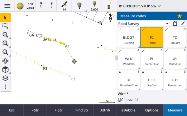
Highlight the current feature with a dashed line to current location
When working in the Measure codes, Measure topo or Measure point screen:
the current feature-coded line is now highlighted in the map.
a dashed line is drawn from the last measured point to your current location.
This makes it easier to see where the next point will be added and if you are stringing linework, to verify that you have selected the correct string.
Prompt only once for line or polygon features
Trimble Access now provides an option to prompt you to enter attributes after measuring only the first point of a line or polygon feature. Previously the software would prompt you to enter attributes after each point in the feature.
Stringing softkeys available in Measure topo and Measure point
When measuring multiple line features that use the same feature code using stringing, we have renamed the softkeys used for increasing or decreasing the string number from + and - to + Str and - Str, and renamed Find to Find Str. The String suffix set in Options now applies to all features codes, previously a different suffix could be configured in Measure codes for individual groups of codes.
The + Str, - Str and Find Str softkeys are also now available in the Measure topo and Measure point screens. Previously stringing softkeys were available only when in the Measure codes screen. Stringing in the Measure topo and Measure point screens only works when using codes defined in the Feature Library FXL file used by the job.
Map tools for working with large datasets
Viewing and managing properties in linked map files
When reviewing properties or attributes for items in a linked map file, for example during stakeout, the software now shows properties in expandable and collapsible groups. To quickly expand or collapse all groups, press Ctrl + Space, or press Ctrl when you tap one of the expand or collapse icons.
To select favorite properties, tap the
next to one or more properties and then tap Refresh to copy the selected properties and their group names to the Favorite properties group at the top of the properties list. Favorite properties must be selected per controller. Once you have added a favorite property, the property always appears in the Favorite properties group if that property is used for the selected item in any linked map file.
For more information, see the topic Reviewing item properties in the map in the Trimble Access Help.
View and update custom property sets for BIM models
Properties in custom property sets that have been added to the BIM model in Trimble Connect can now be viewed and edited in Trimble Access.
To view custom property sets, tap the Property sets
button in the BIM toolbar to download custom property sets applied to the BIM models shown in the map from Trimble Connect. In the map select items in the BIM model and then tap Review. Properties in custom property sets are shown alongside properties contained in the BIM model file.
Custom property sets are a useful way to add properties to the model that inform the office something has changed in the field. If you have a Trimble Connect Business Premium license, you can create custom property sets and assign them to any model element in Trimble Connect without having to access the original authoring tool used to create the BIM model. A Trimble Connect Business Premium license is not required to view or edit custom property sets in Trimble Access.
For more information, see the topic Reviewing custom property sets in the Trimble Access Help.
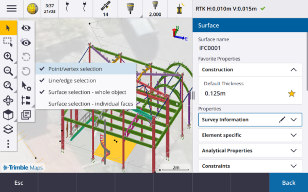
BIM model selection mode tool
We know that selecting the correct part of a BIM model can be a frustrating experience! The BIM toolbar now includes a Selection mode button
so you can choose the types of items that are selectable from a BIM model in the map.
Available selection modes include the Surface selection - whole object and Surface selection - individual faces options that were previously available in the Map settings screen, as well as two new selection modes: Point/vertex selection and Line/edge selection.
Disable item types you do not want to be able to select right now, for example disable line selection when you want to select a vertex rather than the line on which the vertex is located. The
when selection of any item types is disabled.
For more information, see the topic BIM model selection mode in the Trimble Access Help.
Reviewing BIM surfaces
When reviewing multiple BIM surfaces, the BIM surface being reviewed is now highlighted yellow in the map, while the other selected surfaces remain highlighted in cyan. Tap the Next or Prev softkeys to cycle through the selected surfaces.
Tools for connected cloud workflows
Assign tags to jobs
When working in cloud projects, you can now assign tags to jobs to help you stay organized. Set up tags per project in Trimble Connect to keep track of your jobs – for example add tags for project phases or sites. Trimble Access users can assign or remove tags as required in the Jobs screen. Search by tag name in Trimble Connect to easily find the relevant jobs.
For more information, see the topic Managing jobs in the Trimble Access Help.
Other new features and enhancements
Staking to BIM surfaces
In addition to using a topographical surface, the cut/fill can now be computed from surfaces in an IFC model. In the stakeout screen enable the Cut/Fill to surface switch. In the Surface field instead of selecting the surface file from the current project folder, you can select surfaces from BIM files. The Surface field indicates the number of surfaces you have selected in the map.
To compute the cut/fill to a BIM surface when staking a point, in the map select the surface or surfaces in the BIM file, tap Options and enable the Cut/Fill to surface switch, confirm the number of surfaces selected and then tap Accept.
Additional surface deltas are available. To configure the deltas displayed during stakeout, tap Options and edit the deltas.
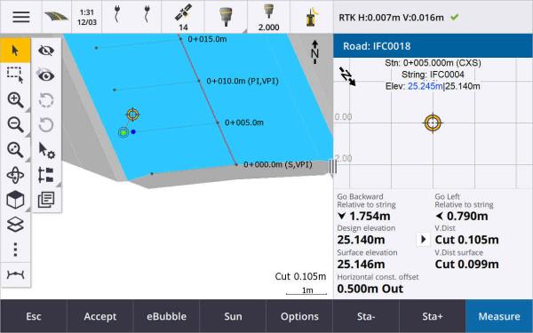
Staking to a surface enhancements
When staking a line, arc, or polyline the option to compute Cut/fill from a surface is easier to access directly from the Stakeout screen. In the stakeout screen enable the Cut/Fill to surface switch and select the surface. In previous versions surface selection was accessed from Options and called DTM.
IFC 4.3 ADD2 support
Trimble Access version 2024.00 reads IFC 4.3 ADD2 files. ADD2 is the official final buildingSMART ISO IFC 4.3 standard.
IFC 4.3 supports linear infrastructure assets including roads, rail and bridges. IFC 4.3ADD2 is a relatively new schema, and there are very few products that can currently create IFC 4.3 ADD2 files. As a Strategic Member of buildingSMART International, Trimble is committed to working with our industry partners on supporting this open, vendor-neutral international standard. If you obtain an IFC file that passes IFC validation service but does not work as expected in Trimble Access, please pass the file to us via your Trimble Distributor.
Attributes for IFC alignments
Attributes for alignments in an IFC file are now saved with stored points when staking an alignment, in the same way Trimble Access saves attributes when staking points or lines from an IFC file.
Upload a local project to the cloud when you create it
When creating a project on the controller you can now select the Create cloud project check box in the New project screen to upload the project to the cloud when you create it.
New Project settings screen
The new project settings screen combines the Project properties screen and the Sync settings screen.
-
To open the Project settings screen, select the project in the Projects screen and tap
 in the project details pane.
 The
icon replaces the Properties softkey in the Projects screen and the  icon in the project pane.
 -
The Project settings screen shows the Properties tab. If the project is a cloud project, it also shows the Connect Files tab, Team tab, and the IBSS tab which were previously available in the Sync settings screen.
-
The Projects screen now has a Delete softkey for deleting a project from the controller.
Changes to cloud settings
-
The Sync scheduler screen has been renamed to the Cloud settings screen to better reflect that it includes settings that are in addition to scheduling.
-
The Upload linked project files as well as field data and exports check box has been renamed to the Upload linked files check box and now applies to all projects on the controller. Previously this setting needed to be configured per project.
-
Linked files uploaded to the cloud from Trimble Access are now not set to be automatically downloaded with the job when another user is downloading the job to their controller. However, the files will be available in the cloud and can be downloaded to other controllers using the Add button in the Layer manager.
Trimble recommends users who are upgrading to version 2024.00 from a previous version should review the Cloud settings (particularly for Upload linked files and the Download as TrimBIM settings). On upgrade to version 2024.00, these settings are both set to off by default for all projects, regardless of how these settings may have been configured for individual projects previously.
Current project folder pinned to file browser
When you select files or folders using the Trimble Access file browser, the current project folder is now one of the pinned locations for This controller.
New Snap to perpendicular tool
The Snap-to toolbar in the map now includes a Snap to perpendicular tool. Use Snap to perpendicular ![]() to create a virtual point at the intersection of the selected point projected perpendicular to the line.
to create a virtual point at the intersection of the selected point projected perpendicular to the line.
If required, the line may be extended to determine the perpendicular intersection.
Code selection now indicates feature type
Each code button in the Measure codes screen now shows an icon in the top left corner to indicate whether the code corresponds to a point, line or polygon feature. The same icon is shown next to the code when selecting the code from the Codes list.
The template icon that was previously in the top left corner of the code button in the Measure codes screen is now displayed at the top center of the button.
Reviewing attributes for multicoded points
When Multicoding points we now show the string number on the header of the attribute form. This helps you identify the difference between two of the same features on one point, for example Fence1 and Fence2.
Feedback when staking past the end of a line
When staking lines (including arcs or polylines), the software now shows the Station value in red text if you are positioned before the start or after the end of the line.
Updates to export stylesheets
We have updated the following export stylesheets, which are installed with Trimble Access:
-
CSV with attributes.xsl
-
CSV Global Lat-Long points.xsl
-
Check shot report.xsl
All three reports now include an Optional start date for report and an Optional end date for report. You can tap ![]() next to the date field to access a date picker tool that makes it easy to set today's date, or to set any other date.
next to the date field to access a date picker tool that makes it easy to set today's date, or to set any other date.
The CSV with attributes.xsl file now includes an option to Export attributes (select Yes or No). Exported attributes include the attributes collected with codes in Trimble Access, but not attributes stored from points with properties or attributes in linked files.
Web map enhancements (WMS, WMTS, WFS)
Trimble Access version 2024.00 includes the following enhancements for web maps:
- When creating an instance of the WFS to use in Trimble Access you can now select the georeferenced vector layers from the WFS to include, and then use the map toolbar to zoom and pan the map to the extents required before downloading the data to the file.
- When using a WMS, Trimble Access now detects the format of the images for display.
- If you select Web Mercator as the coordinate system for a WMS or WMTS, and you know that the WMS or WMTS server uses Web Mercator coordinates referenced to the same datum as your job rather than WGS 1984, you can now select the Use job datum check box to correct for a possible misalignment in the image data of up to 1-2 meters when the Web Mercator coordinate system is based on an underlying datum that is not WGS 1984.
For more information, see the topic Web maps in the Trimble Access Help.
IMU tilt compensation available during RTK & infill surveys
When Trimble Access is connected to a GNSS receiver that supports IMU tilt compensation, you can now survey points using IMU tilt compensation during the RTK part of an RTK & infill survey. The IMU is automatically disabled during the postprocessed infill part of the RTK & infill survey, and is automatically re-enabled when the survey returns to RTK.
IMU tilt compensation is available during RTK & infill surveys only when logging to the controller, not to the receiver.
Negative Horizontal tilt offset values
When measuring a Horizontal tilt offset using a GNSS receiver that has IMU tilt compensation enabled and a properly aligned IMU, you can now enter a negative value in the Offset field.
Usually the pole is tilted toward you – in this case you will enter a positive value. If you need to tilt the pole away from you, then enter a negative value.
For more information, see the topic To measure a horizontal tilt offset point in the Trimble Access Help.
New RTX(SV) survey style
Trimble Access 2024.00 installations now include a new RTX(SV) survey style, along with other default survey styles created at startup.
Starting April 1, 2024, newly purchased Trimble R12i, R780, R580 and R750 GNSS receivers will include an activated and ready-to-use Trimble RTX subscription for the first 12 months. Annual renewal options are available for continued access.
In Trimble Access, select the RTX(SV) survey style and you are ready to survey. If needed, you can edit the survey style to change the constellations you want to track.
When upgrading from an older version of Trimble Access, the new RTX(SV) survey style is not created automatically. To take advantage of the included RTX subscription, you can manually create a new RTX(SV) survey style.
IBSS stream renamed to IBSS mountpoint
After feedback from users, we have changed the terminology used when configuring and managing IBSS correction sources from "stream" to "mountpoint".
Trimble IonoGuard (Ionospheric Mitigation) support
The Receiver settings screen in Trimble Access now displays whether Ionoguard is Enabled, Disabled, or Not supported in the connected receiver. Starting in firmware 5.61/6.21, Trimble Survey GNSS firmware includes Trimble IonoGuard™ technology for ionospheric disturbance mitigation.
The impact of the solar flares/ionospheric interference depends on your device and geographic location.
Prompt to disconnect internet when ending an RTK internet survey
When ending an RTK survey using an RTK internet data link that uses the connected receiver's internal modem, before showing the message asking whether to power down the receiver, Trimble Access now shows an additional message asking "Disconnect internet connection?".
-
Tap Yes to end the connection to the modem, which also ends the corrections stream.
-
Tap No to end the corrections stream but leave the receiver online ready for the next survey.
Whether you select Yes or No, the software now ends the corrections stream when the survey ends. This avoids unintentional use of cellular data and VRS hours.
Context ID selection on receiver SIM card
When configuring an RTK internet data link, if you are using a SIM card in the receiver that has more than one context ID, you can now use the CID field in the Receiver internet - modem configuration screen to select the context ID. To get the defined context IDs from the SIM card in the receiver, tap ![]() and select Load from modem and then select the CID to use.
and select Load from modem and then select the CID to use.
Alignment stationing settings when using video
When connected to an instrument that has video and viewing the Video screen during alignment stakeout, when you select a station from the list the station settings fields are now available.
Use the station settings fields to define a station interval for lines and a separate station interval for arcs and transitions, select the available station types, and to select the method used to increment the station interval.
Viewing map files in the instrument video screen
The following additional map file types can now be shown over the video feed from the connected instrument:
-
linked point and line files (DXF, LandXML, 12da, Shapefiles)
-
linked road files (RXL, LandXML, GENIO)
- linked mining files (Surpac STR)
Previous versions of Trimble Access supported only linked BIM model files
To enable data overlay, from the Video screen tap ![]() to open the Video settings screen, and in the Map files group enable the Overlay on video switch.
to open the Video settings screen, and in the Map files group enable the Overlay on video switch.
Performance improvements
-
We have improved the performance speed of the software when using a surface file (for example a DTM file) during stakeout.
-
We have improved the performance speed of the software when loading a 12da file.
Enhanced support for FXL feature libraries
For feature library FXL files created using the Feature Definition Manager in the Trimble Business Center software:
-
Trimble Access now supports extended list attributes, where users can select more than one item from the list.
- Read only attributes are shown but cannot be edited in Trimble Access.
-
Office use only attributes are not shown in Trimble Access.
FXL attributes previously defined as Office use only are no longer displayed in Trimble Access. If you require the attributes to be shown in Trimble Access then update the FXL to change them from Office use only to Read only.
Favorites and functions
In the Assign special functions screen, the following functions previously grouped under Measure codes are now available in the Survey group:
-
Find string
-
String -
-
String +
-
Multi-code
For more information, see the topic Favorite screens and functions in the Trimble Access Help.
Bluetooth permissions on controllers running Android
When using Trimble Access on a controller running Android, you are now prompted to set the appropriate Bluetooth permissions when required.
If you have previously denied Bluetooth permissions in the Android Settings screen, then Trimble Access cannot prompt you for permission. To manually allow permissions, go to Android Settings and configure the App permissions for the Trimble Access app to allow permissions to Nearby devices.
Units for mass values
You can now set the units used for mass values in the job. Configure job units from the Job properties screen. Available Mass units include kilograms, tons (metric, US, or imperial) and pounds.
Cadastral point tolerance checking for Norway
Trimble Access now provides the ability to check measured or staked out points have been measured twice ("double‑tied") and that they meet Norwegian cadaster regulations for being within tolerance.
To use Norwegian cadastral point tolerance checking in Trimble Access you will need to download the sample CadastralTolerances ‑ Norway.xml file from the Configuration files page of the Trimble Access Help Portal and add it to the Trimble Data\System Files folder on the controller.
Once you have enabled cadastral tolerance checking in the job, the Trimble Access software automatically checks the tolerances for cadastral points in the job when you stake a point or compute an average of two or more points. The status of each cadastral point is displayed on the map and is summarized in the job screen.
For more information, see the topic Cadastral point tolerance checks in the Trimble Access Help.
Japanese characters in data entry fields
You can now enter Japanese characters in fields in the Trimble Access software, for example when entering the job name.
Japanese alignment labels
Japanese station labels are used by default when Japanese is the selected language in the Languages screen.
You can change these settings in the Japanese settings group box in the Additional settings screen. The Japanese settings group box is available only when Japanese is the selected language.
Updated computation of Elevation scale factor
Trimble Access now uses the Mean curvature radius when computing the Elevation scale factor. This matches the calculation used by Trimble Business Center.
Previous versions of Trimble Access used the Transverse radius in the computation of Elevation scale factor. The difference in the two formulae resulted in a scale factor difference of a few parts per million.
For more information, see the topic To set up a ground coordinate system in the Trimble Access Help or refer to the Ground scale factor section in the Trimble Access Calculations Reference Guide.
Coordinate System Database updates
The
-
Modernized support for the Philippines.
-
Modernized support for Tanzania with TAREF11 and EGM2008.
-
Added support for Guatemala.
-
Added support for Wisconsin Transverse Mercator.
-
Updated geoid model for Romania to ROvT4.08.
-
Fixed incorrect values in AusGeoid2020 geoid model for Australia.
-
Added new geoid model RAC23 for Corsica.
-
Added new geoid model DVR90 2023 for Denmark.
-
Added new ITRF2020 plate motion model.
-
Updated predefined zones for Slovakia.
-
Fixed RTX with Lambert county zones in Minnesota and old county zones in Wisconsin.
-
Updated Germany/DB (Deutsche Bahn) zones. Renamed local datum from DB_ETRS2DHDN to DB_REF and updated reference global datum from WGS 1984 to ETRS89-DREF91(R16).
-
Support for all realizations used in California.
-
Added latest geoid model FIN2023N00 for Finland.
Hardware support
Trimble DA2 GNSS receiver
Trimble Access version 2024.00 supports the new, lightweight Trimble DA2 GNSS receiver. Part of the Trimble Catalyst™ GNSS positioning system, the DA2 receiver wirelessly connects to the controller using Bluetooth to provide fast, accurate positioning to 1 cm (0.032 ft or 0.39") with a Catalyst Survey subscription.
The Catalyst Survey subscription provides access to the Trimble Corrections Hub, which dynamically selects the appropriate Trimble VRS Now™ or Trimble RTX® correction service based on your location and service availability. If required, you can configure the Trimble Access software to receive corrections from an NTRIP caster via the internet instead of the Trimble Corrections Hub.
To use a Trimble DA2 GNSS receiver with Trimble Access you must have a Trimble Access subscription and a Catalyst Survey subscription. Other Catalyst subscription types cannot be used with Trimble Access.
Trimble R780 GNSS receiver
Trimble Access version 2024.00 supports the Trimble R780 GNSS model 2 receiver. Support for the Trimble R780 GNSS model 1 receiver was added in Trimble Access version 2022.10.
The ultra-rugged R780 GNSS receiver is built to handle the toughest survey environments. The R780 supports IMU tilt compensation, enabling accurate measurements to be taken without having to level the antenna, so that you can work faster and more efficiently in the field. Adaptable and scalable, choose the features you need at purchase, with flexibility to add more functionality as your requirements change in the future.
Trimble TDL450B UHF radio
Trimble Access version 2024.00 supports the new Trimble TDL450B UHF radio. The IP67 rated rugged radio can connect to Trimble GNSS receivers using Bluetooth or a cable to broadcast, repeat and receive data used by the receiver for RTK GNSS surveys.
Trimble TDC6 handheld data collector
Trimble Access version 2024.00 supports the new Trimble TDC6 handheld
You can use the Trimble Access software when using the TDC6 in portrait mode or landscape mode.
The TDC6 can connect to all supported GNSS receivers and most conventional instruments using Bluetooth. The TDC6 can also connect to all supported Trimble conventional instruments using a cable.
To perform a robotic survey when Trimble Access is running on the TDC6 handheld, you will need to connect the TDC6 to the TDL2.4 Radio Bridge or EDB10 Data Bridge.
Trimble T10x (2024) tablet
Trimble Access version 2024.00 supports the new Trimble T10x (2024) tablet, a thinner and lighter tablet that is rugged and durable enough to withstand the rigors of any survey job. With superior processing power, the T10x (2024) provides unmatched efficiency for scanning workflows.
T-360 LED and T-360SL LED target
Trimble Access version 2024.00 supports the T-360 LED and T-360SL LED targets. The T-360 LED and T-360SL LED targets are reflective foil targets designed for use as active tracker targets, and are available only in Japan.
Resolved issues
- Auto sync in progress: We have fixed an issue where occasionally the software would show the message Auto sync in progress, please wait, preventing you from performing other actions such as changing projects.
- Sync scheduler upload warnings: We have fixed an issue where if the Automatic upload option had been enabled and was then disabled when changes had been made to files but not yet uploaded, the software continued to warn that there were changes in the files that needed to be uploaded.
- Uploading job changes: The software is now less likely to show a job has changes that must be uploaded to the cloud if the only action taken was to open the job.
-
Disallowed project names: We have fixed an issue where Trimble Access would allow project names with trailing fullstops or periods. This resulted in the project folder becoming unreadable. Trailing fullstops or periods in project names are now disallowed.
- Geoid file selection: We have fixed an issue where after selecting a coordinate system that uses a geoid model, the software did not always allow you to enable the Use geoid file switch.
- Japanese geoid download: We have fixed an issue where if you selected one of the Japanese State Plane 2011 zones and did not have the GSI Geoid 2011 v2.1 on your controller, then Trimble Access would incorrectly download gs1geo11.ggf (GSI Geoid 2011) instead of gsigeo11v2.1.ggf.
- File browser: We have fixed an issue with the Trimble Access file browser, where sorting files by the last modified date was very slow.
- Job import from network drive: We have fixed an issue where attempting to import a job file from a network drive failed.
- Job export to PDF: When using Trimble Access on a controller running Android, you can now export PDF reports to any target folder on the controller, including folders on an SD card or USB drive. Previously errors could occur when the View created file option was selected during export.
- LAS point cloud export: We have fixed an issue where Trimble Access was specifying the file contained an incorrect number of records in the file header, which caused some software to have issues reading the file.
-
Layer manager: We have fixed the following issues with the Layer manager:
- Jobs and linked files stored in subfolders in a project were not shown in the Layer manager.
- When you set a CSV or TXT file that was linked from outside the current project folder to not visible in the Point files tab, the file remains in the Layer manager until you change jobs or restart Trimble Access. This is consistent with the behavior in the Map files tab.
- Map backgrounds not shown: We have fixed an issue when viewing a job created from another job or from a template, where the map background files are not automatically shown in the new job and have to be re-enabled in the Layer manager. This issue affected any map backgrounds including images or web map services.
- WMTS service not showing map data: We have fixed an issue when using a WMTS service that uses a coordinate system where the order of coordinates is Easting-Northing rather than the expected Northing-Easting. Trimble Access now uses the EPSG definition to determine the correct order of coordinates for a WMTS.
- WFS service not showing map data: We have fixed an issue when using a WFS service that uses WFS 1.1, where Trimble Access reported the connection was correctly set up but no data was displayed. WFS 1.0 and WFS 2.0 is already supported in Trimble Access.
- Dot symbols on Android controllers: We have fixed an issue when using a controller running Android where dot symbols did not appear on the map when Dot symbols was selected from the Symbols field in the Map settings screen.
- Joining lines as polylines: We have fixed an issue introduced in Trimble Access 2023.01, where if you attempted to join two lines from a linked file to create a new polyline, the software incorrectly warned of "an invalid polyline definition".
- Properties for IFC points: We have fixed an issue when creating points from an IFC file where if multiple IFC points are created using the tap and hold option Create points, then the properties for only the first point were stored and properties were missing for the other points.
-
Feature coded linework: We have resolved an issue where the feature coded linework:
-
Was not drawn between two points where the first point is at the same coordinates as another point.
-
Was not drawn correctly after using the No join control code.
-
Resulted in an extra line drawn across the chord of the arc when a feature coded polygon ended in an arc.
-
- Offset points in map/video: The overlaid graphics in the map and video screens now update when offset points are added. Previously, the overlaid graphics did not update to include offset points until the map or video screen was refreshed (for example by panning or zooming).
- Design elevation for offset points: It is no longer possible to edit the design elevation when setting an offset for a point during stakeout. In previous versions it was possible to edit the design elevation but the new value was not used.
- As-staked points stored as normal points: We have fixed an issue where as-staked points were sometimes stored as points with a classification of "Normal" if the observation method was changed in the as-staked point form before the point was measured.
- Vibrate on point storage: We have fixed an issue where the controller did not always vibrate when Trimble Access auto stored a point or when a point was ready to be stored, despite being configured to do so in the Settings / Languages screen.
-
Station setup: When using a free scale station setup, the scale factor is now correctly recomputed if the back sight is re-measured.
-
Copy last station setup: When using Copy last to use the last completed station setup in a different job, all targets used in the station setup are now copied into the job.
-
Default code after check backsight: We have fixed an issue where after checking your backsight using the shortcut CTRL + K, the Measure topo form would not correctly default to the last used code.
-
SX12 connections: We have improved transitions from cable connection to Wi-Fi connection for the SX12 within Trimble Access.
- SX12 password: We have improved the software behavior when attempting to connect to an SX12 with password support enabled.
- SX10/12 images not linked: We have fixed an issue where snapshots captured using a Trimble SX10 or SX12 scanning total station instrument were not correctly linked to the point in the job when the Geotag images option was enabled in the Trimble Access software.
- F2 Auto turn: We have fixed an issue when measuring F1 and F2 observations where if the Servo/Robotic settings Automatic and Auto turn were disabled, then the software disregarded the Auto turn setting and always automatically turned to the calculated F2 position.
- Continuous topo with IMU: When the QC1 & QC3 option is selected in the survey style, QC3 data is now stored with points when measuring continuous topo using IMU tilt compensation.
- Incorrect SV reporting: When using the internal GNSS on some controllers, the number of satellites (SVs) being tracked was sometimes unusually high. The number of satellites being tracked was correct when connected to an external GNSS receiver.
-
Receiver Wi-Fi: We have improved the behavior of the Wi-Fi tab in the Connections screen where:
-
the software sometimes showed a spurious communication error when first opened.
-
deleted networks are no longer shown.
-
-
Start base survey: We have fixed an issue when starting a base survey with a Spectra Geospatial receiver, where the receiver displayed an error and/or beeped repeatedly. This issue was due to incompatible settings in the survey style, where the Bandwidth limit had previously been set in the Base data link form of the base survey style, and you then changed the antenna type in the survey style to a Spectra Geospatial receiver that does not support bandwidth limiting.
-
Geotagged photos: Geotagged photos that have a negative elevation now have the correct elevation value.
-
Measure codes: We have fixed the following issues when using Measure codes:
-
When using codes that ended in a number the software did not recognize the base code when drawing linework after adding a String suffix.
-
The entire contents of the Multicode field are now highlighted when you return to the Measure codes screen from the Measure topo or Measure point screen.
-
-
Application errors: We have fixed several issues that caused occasional application errors when using or closing the software. In particular:
-
When attempting to run Trimble Access on a controller running Android 12 or later when you have inserted a removable drive from which folders that you had previously given access permissions have been deleted.
-
When downloading a project from the cloud when the project is in a folder that the signed in user does not have access to.
-
After choosing the Add points to CSV file option without entering the name of the CSV file.
-
When exiting the Feature libraries screen after accidentally opening two instances of the Feature libraries screen.
-
When deleting triangles from a DTM file.
-
When importing a file in a supported file format that is incorrectly encoded as a binary file. Correctly encoded files are encoded as UTF-8 or MBCS.
-
When loading shapefiles where the geometry information in the header was incorrect.
-
When keying in a polyline using GNSS points from a linked job.
-
When attempting to view information in Point manager for points that included observations from IRNSS/NavIC satellites.
-
When renaming a resected point in Point manager.
-
When starting a base survey when the Radio field in the Base data link screen in the survey style is set to ADL Vantage.
-
When changing the display size in the operating system settings on a controller running Android.
-
When viewing a TSF scan file from the Review job screen on a controller oriented to portrait mode.
-
When attempting to export scan points without first opening the job. You must now open the job before being able to export scan points.
-
When copying and pasting text between forms and one of the forms closes unexpectedly, for example when an instrument disconnects.
-
When exiting the software. In addition, the software no longer allows additional user actions when in the process of closing.
-
