2022.00
Version 2022.00 of the Trimble Access software is available from May 2022.
These Release Notes describe the new features and changes available in this release of the
New hardware support
Trimble R780 GNSS receiver
Trimble Access version 2022.00 supports the new Trimble R780 GNSS receiver.
The ultra-rugged R780 GNSS receiver is built to handle the toughest survey environments. Adaptable and scalable, choose the features you need now, with flexibility to add more functionality as your requirements change in the future.
Trimble TDC650 handheld GNSS receiver
Trimble Access version 2022.00 supports the new Trimble TDC650 handheld GNSS receiver.
The TDC650 can be used as a handheld, with a monopole using the integrated antenna, or mounted on a pole and used with an external antenna.
The TDC650 can only be used with Trimble Access subscriptions, and is designed for GNSS‑only surveying using the integrated GNSS receiver. It does not support connections to external GNSS receivers or total stations
Improved support for Android 11
Trimble Access version 2022.00 improves support for Android 11. In particular:
-
Improved handling of Android location permissions, required for Bluetooth, Wi-Fi, and internal GPS.
-
Resolved issues when connecting to or using an SX10/SX12 scanning total station.
All users that upgrade their TSC5 controller to Maintenance Release 3 of the operating system (MR3) are strongly encouraged to upgrade to Trimble Access 2022.00.
Trimble Precise Active target
Trimble Access version 2022.00 supports the Trimble Precise Active target.
This target is designed to allow Trimble S Series active tracking to be used in high precision engineering applications. The target should be used at a vertical angle within +/‑ 15° from horizontal. If the vertical angle is greater, tilt the target toward the instrument.
For more information, refer to the Trimble Track Surveying & Scanning product catalog.
New features
Automate data upload using the Sync scheduler
Use the Sync scheduler screen to automate synchronization to the cloud for the current project. To open the Sync scheduler screen, tap  in the Projects screen.
The settings in the Sync scheduler screen are saved to the controller and applied to any cloud project when it is the current project. This means you can configure these settings once and you don't need to configure them again for new projects.
For example, if you have three projects and you set the Sync scheduler to upload data to the cloud every hour, then only the current project will upload data to the cloud every hour. If you open a different project, then data in that project is now uploaded to the cloud every hour.
Choose whether to upload data at regular time intervals or after specific events, for example when closing a job or when signing in. You can choose whether to allow automated upload when connected to any network or only when connected to specific networks.
For more information, see the topic Automating data upload using the Sync scheduler in the Trimble Access Help.
Support for web feature services (WFS)
You can now request geographical features as georeferenced vector data over the Internet using a web feature service (WFS), and then save the data as a WFS file so that you can use it in the field without an Internet connection.
Supported web feature services in Trimble Access are the Esri Feature Service and Open Geospatial Consortium (OGC) web feature services. Depending on the service, data is provided in GeoJSON or GML format.
Once you have created the WFS file, you can select lines or polylines from the WFS file in the map and stake them. You can also create points at the ends of lines and at all points along a polyline, by selecting the Create nodes (DXF, Shape & LandXML) check box in the Map settings screen. The created points can then be selected for stakeout or Cogo calculations.
For more information, see the topic To manage web map & web feature services (WMS or WFS) in the Trimble Access Help.
DWG and NWD BIM model support
In addition to IFC and TrimBIM files, Trimble Access on Windows now supports two additional BIM model file formats:
-
Drawing (.dwg) files created using Autodesk AutoCAD software
-
NWD (.nwd) files created using Navisworks software
Trimble Access supports the reading of standard AutoCAD entities from DWG files. Objects created by AutoCAD extensions may not be supported. In particular, Trimble Access is unable to read Civil 3D objects from DWG files. Visit Autodesk's Knowledge Network to learn how to convert Civil 3D drawings to standard AutoCAD format.
We have renamed the IFC group box in the Map options screen
You can use any supported BIM model file format in Trimble Access for surveying fieldwork including measuring points, stakeout, and cogo calculations including scan to surface inspections, and center point or centerline calculations.
For more information, see the topic BIM models in the Trimble Access Help.
Download BIM models as TrimBIM files
BIM models are not supported when running Trimble Accesson an Android device. This limitation applies to all types of BIM models, including IFC, TrimBIM, DWG, and NWD files.
The Sync settings screen now provides the Download as TrimBIM check box to download BIM or 3D models (including Industry Foundation Classes (IFC), Navisworks Drawing (NWD), AutoCAD Drawing (DWG) and SketchUp (SKP) files) from Trimble Connect as TrimBIM files. TrimBIM files are smaller, faster to download to the controller, and faster to load the first time you use them in Trimble Access. Alternatively, to use IFC, DWG and NWD files in their original format, clear the Download as TrimBIM check box.
Conversion of NWD files to TrimBIM format using Trimble Connect is in BETA. It is only supported when you upload NWD files to Trimble Connect using Connect Desktop, not Connect Web.
For more information on assimilating BIM models as TrimBIM files in Trimble Connect, refer to the Trimble Connect documentation.
Staking an alignment from an IFC file
We now support the IfcAlignment element introduced in the Industry Standard IFC 4.1 schema. You can now stake out an alignment from an IFC file in the same way that you stake a single alignment from an DXF, RXL, or LandXML file.
Georeference map Cogo adjustment
The new Georeference map Cogo Adjust function allows you to match locations in a map file to points in the job. This is useful when, for example, an architect provides coordinates for a building foundation that needs to be positioned and transferred into a real coordinate system on site. You can use the Georeference map function to transform the model into the grid coordinate system used by your Trimble Access job.
The Georeference map function uses a combination of translation, rotation and scale to shift the map file so that the selected map file locations match the selected points. If you choose only one point, then the transformation uses a translation only.
Selected map file locations must be entities you can select in the map, such as vertices in a BIM model or points or nodes in a DXF file.
If the first map files you link to the job are BIM models or DXF files in a location coordinate system that are located far from existing job data, then the software now warns that the map file is far away from the job data and suggests georeferencing the file. Tap Yes to allow the software to perform an approximate georeference by relocating the center of the map file close to the existing job data, and then use the Georeference map function to fine-tune the georeferencing.
For more information, see the topic Georeference map in the Trimble Access Help.
Horizontal tilt offset point measurement method for GNSS survey
When using a GNSS receiver that has IMU tilt compensation enabled and a properly aligned IMU, you can use the Horizontal tilt offset method to measure locations that cannot be occupied by the tip of the pole, for example when measuring the center of a tree or post.
The Horizontal tilt offset method uses IMU tilt compensation to calculate the azimuth of the tilted pole between the Antenna Phase Center (APC) of the GNSS receiver and the pole tip, and then projects the reciprocal of the azimuth (1) forward from the tip at the specified offset distance (2) to compute the offset point:
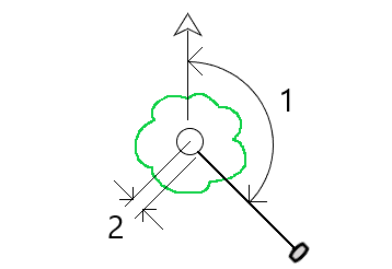
When measuring, tilt the pole more than 15° and then sight down the pole so that the center of the receiver, the pole, the pole tip, and the offset point being measured (for example, the center of the tree) are in a straight line (on the same azimuth). The azimuth at the time of point storage is the azimuth used for the offset.
For more information, see the topic To measure a horizontal tilt offset point in the Trimble Access Help.
Cadastral point tolerance checking
Trimble Access provides the ability to check measured or staked out points have been double‑tied to ensure they meet the cadaster regulations for being within tolerance. To date, this feature has been developed to meet cadaster regulations in Switzerland. If your country uses the same cadastral tolerance checking rules you may be able to use this functionality in your own region.
To use this functionality in Trimble Access you will need to add an XML file to the Trimble Data\System Files folder. The XML file defines the cadastral codes and specifies the different tolerance requirements for the type of point being measured or staked.
Once you have enabled cadastral tolerance checking in the job, the Trimble Access software automatically checks the tolerances for cadastral points in the job when you stake a point or compute an average of two or more points. The status of each cadastral point is displayed on the map and is summarized in the job screen.
For more information, see the topic Cadastral point tolerance checks in the Trimble Access Help.
Enhancements
Receiver Wi-Fi connections
Trimble Access now supports the set up and use of a receiver Wi-Fi connection in both rover and base surveys. This was previously only configurable using the Trimble GNSS receiver WebUI, and allows for easier configuration of Internet base station surveys when using an external device for Internet connectivity, such as a cell phone or MiFi device.
GNSS data logging to the controller
Logging GNSS data to the controller during a logging survey (Fast static, PPK, RTK and logging, RTK and Infill) now includes data from Galileo, QZSS and BeiDou satellites. Previously only data from GPS and GLONASS satellites could be logged to the controller. Logging GNSS data to the receiver already includes all GNSS constellations.
L5 GPS signal tracking in an RTX survey
You can now enable tracking of L5 GPS signals during an RTX (SV) or RTX (Internet) survey.
Prompt for sign out to release subscriptions on exiting the software
Trimble Access customers using subscriptions typically use the same controller and leave their subscription locked to the controller. You must sign out on the current controller before you can use your subscriptions on a different controller. We have now made this process easier to manage.
If you don't always use the same controller, you can now configure the software to release your subscription licenses automatically when exiting the software, or to prompt you to sign out and release your subscription on exit. To do this, tap ![]() and select About, and then select the appropriate option from the When exiting the software field.
and select About, and then select the appropriate option from the When exiting the software field.
CSV format improvements when importing or linking CSV files
We have improved the handling of CSV files during import or when linking, including:
-
Header lines are now ignored
-
CR and LF characters at the end of each line are now ignored
-
Files with ANSI, UTF8, and UTF16 characters are supported
Ordering points when exporting to CSV
When exporting points to a CSV file, if you have selected the points from the map or from a list you can now reorder the selected points by tapping the Name column in the Points to export list.
Adding measured points to a CSV file during a GNSS survey
You can now add points measured using the Measure points method during a GNSS survey to a CSV file. Previously, only points measured during a conventional survey could be added to a CSV file. This option allows you to add specific measured points to a CSV file, for example an observed control point.
To enable this option, in the Job properties screen tap Additional settings and then in the Add to CSV file group box, move the Enable switch to Yes and enter the CSV file name or browse to the file and select it.
When this option is enabled, an Add to CSV file check box appears in the Measure points form during a GNSS survey or the Measure topo and Measure rounds forms during a conventional survey. Select the check box to add the current point to the CSV file.
Code descriptions now included on Measure codes buttons
The code description is now included with the code on each button in the Measure codes form. This makes it much easier to know which code to use. To show only the code, tap Options and clear the Descriptions check box.
Last used attributes now remembered when coding with string numbers
When Use attributes of base code is enabled and you are using string numbers, Trimble Access now remembers the last used attributes for each string, not just the base code. For example, if the last used attribute for FENCE1 was Condition GOOD, and FENCE2 was Condition POOR, then you can jump between using FENCE1 and FENCE2 as you are measuring points along the fence and the appropriate last used attributes will be remembered. Previously, the software would have offered only the attributes for the last used fence, which meant attributes needed to be edited when jumping between two strings.
Attributes on linework
When storing a code with attributes on a line, arc, or polyline, you can now enter and store attributes.
Creating job from JXL file auto-populates job name
When creating a job from a JXL file, the Job name field now auto-populates with the name of the JXL file.
Polyline stakeout
You can now apply a side slope to the left of a polyline with a zero hinge offset. To do this enter 0.00m/ft and then tap ![]() and select Left.
and select Left.
Include screen captures and snapshots in Survey reports
To create a screen capture of the current map view, tap  . If required, annotate the screen capture using the Draw tools and tap Store. To save the screen capture to the job, tap Store.
If you select the Survey report file format when you export the job, any screen captures saved to the job are automatically included in the report.
Instrument video enhancements
-
The instrument Turn buttons are now easier to tap, as we have increased the size of the active area for each Turn button.
-
The video feed now automatically resizes to avoid being covered by any toolbars.
Design elevation keypad shortcut
During stakeout, when you have an editable design elevation, you can now press the Space key on the controller keypad to edit the design elevation or to reload the original elevation without having to tap the screen.
DTM stakeout deltas
When staking a DTM, the perpendicular cut/fill delta to the surface can now be reported as well as the vertical delta. When staking an entity relative to a DTM, you can configure the software to show the Perp. dist to DTM stake out delta in the stakeout navigation screen. To change the deltas during stakeout, tap Options in the Stakeout screen and then tap Edit in the Deltas group box.
IFC file enhancements
-
When an IFC object contains a GUID the GUID can now be reviewed, as well as stored along with the other attributes.
-
When staking an IFC object, and you set the As-staked code to Design file attributes, a code is created for the as-staked point from the IFC attribute group names, and the attributes for each group are stored with the point. In Trimble Access 2022.00 you can store the IFC attributes as well as add additional codes with attributes, if needed.
-
Points created from an IFC file (for example when you select a point in an IFC file and from the tap and hold menu select Create point) or points that are copied to the job automatically (for example when you compute an inverse between two points) now record the IFC attributes with the points stored to the job.
Surface inspections now supported on Android devices
You can now perform a surface inspection when running Trimble Access on a supported Android device.
The Surface inspection cogo function compares the scan point cloud of an as-built surface with a reference surface and calculates the distance to the reference surface for each scan point to create an inspection point cloud. Only scans created using a Trimble SX10 or SX12 scanning total station can be used in the surface inspection.
Supported surface file types are DTM and TTM, and files that include selectable surfaces (DXF, RXL, TXL, 12da). BIM models are not supported when running Trimble Access on an Android device and you cannot perform a surface inspection to them.
For more information, see the topic Surface inspection in the Trimble Access Help.
Object oriented setup enhancements
-
When using the point, edge, plane station setup method, the software now saves the "virtual" points on the edge and plane as points in the job so that there is a record of the positions used in the station setup.
-
Station residuals are now calculated for the known points method.
-
Both Face 1 and Face 2 are now supported when performing an object oriented setup.
The object oriented station setup is available only when the Object Oriented Setup Trimble Access software option is licensed to the controller. To purchase a license for the Object Oriented Setup option, contact your Trimble Distributor.
BIM model display enhancements
-
When selecting a surface in a BIM model the Trimble Access software highlights the outside surface blue and now highlights the inside surface red. Sometimes BIM models are not oriented correctly and the surfaces are back to front. In many instances this does not matter, for example Compute center point, Compute center line and Measure to surface are not sensitive to which surface face is selected. However, Surface inspection and the Point, edge, plane method when performing an object oriented setup are both sensitive to the displayed surface orientation. To select the other face of the selected surface, tap and hold in the map and select Reverse faces.
-
When viewing BIM models in the Map
To change the Display setting, open the Map settings
Orbit data freely when using XYZ (CAD) coordinates
When the job Coordinate order is set to XYZ (CAD), tap  to orbit data freely in the map, with no constraint.
When the job is not using XYZ (CAD) coordinates, the orbit function is constrained so that the Z axis remains upward.
Exporting to GNSS Vector Exchange (GVX) format
You can now export job data to the GNSS Vector Exchange (GVX) format.
GVX, developed by the US National Geodetic Survey (NGS), provides a standard file format for exchanging GNSS vectors derived from varying GNSS survey methods and manufacturer hardware. The file format includes all of the necessary data of a GNSS vector for inclusion in a survey network for least squares adjustment, as well as crucial metadata. For more information, go to https://geodesy.noaa.gov/data/formats/GVX/.
Using the Project height from a point or the GNSS receiver
When defining or editing the coordinate system, you can now automatically complete the Project height field using the Here or Point softkey when the Coordinates are Ground (keyed in scale factor) or Ground (calculate scale factor). Previously these options were only available when the Coordinates were Grid.
Tap Here to use the current autonomous height derived by the GNSS receiver, or tap Point to use the height of a point in the job or in a linked file.
The Point softkey is not available when you are creating a new job. The Here softkey is available only when the software is connected to a GNSS receiver.
Negative Project height values
When defining or editing the coordinate system, you can now enter negative values in the Project height field, if required.
Take measurements using FOCUS 35 Power key
During a survey you can now take a measurement using a short press of the Power key on the FOCUS 35 total station.
Previous versions of the Trimble Access software already allow measurements using the Power key on the FOCUS 50 total station.
Trimble Access software now available in Indonesian
You can now view the Trimble Access software in Indonesian. To be able to select Indonesian in the Select language screen of the Trimble Access software, you must install the Indonesian language and help files using Trimble Installation Manager.
Coordinate System Database updates
The Trimble Coordinate System Database installed with Trimble Access includes the following enhancements:
-
Added datum and zones for SIRGAS-Chile 2021 used in Chile
-
Added displacement model, datum and zones for RDN2008 used in Italy
-
Added datum and zones for BGS2005 used in Bulgaria
-
Added datum and zones for MAGNA-SIRGAS(2018) used in Colombia
Independent installation of Trimble Coordinate System Database
The Trimble Coordinate System Database (CSD) contains definitions of datums, projections and geoids used in the transformation of Global coordinates to Grid. Past versions of Trimble Access have always included the latest version of the CSD at the time of release. Starting from Trimble Access version 2022.00, the Coordinate System Database appears as a separate item in Trimble Installation Manager. This will enable future updates of the database without requiring a new version of Trimble Access to be installed.
We’re making word choices that support inclusion in our code, products and conversations
When it comes to creating an inclusive environment, we all know that words matter. Occasionally in our work we encounter words and technical jargon that can be considered offensive and non-inclusive due to their origins or associations.
In Roads, we now use the term alignment instead of master string in a GENIO file. This is also consistent with the use of the term alignment in other road types.
In Pipelines, we now use the term primary tally file set instead of master tally file set.
Resolved issues
-
Controller remains on during upload/download: Trimble Access now prevents the controller going to sleep when uploading files to or downloading files from the cloud. This is useful when synchronizing large amounts of data.
-
Points added to CSV uploaded with job: When the Add to CSV file option is enabled, the CSV file containing the points added during the survey is now uploaded to the cloud with the job.
-
Upload triggered by job status change: We have fixed an occasional issue where the last records in a job file were not uploaded to the cloud when the job status field was used to trigger the upload.
-
.0 appended to project name: We have fixed an occasional issue where a project on the controller loses the connection to the cloud project, resulting in two projects with the same name appearing on the controller, with .0 appended to one project name.
-
Filtering jobs: The project details pane to the right of the Projects list now shows the same jobs as the Jobs screen when you are filtering jobs.
-
Upgraded job issues: We have fixed an issue where a Trimble Access job upgraded from reference frame HTDP v3.2.9 to HTDP v3.4.0 could not be opened in Trimble Access or imported to Trimble Business Center.
-
Import ASCII file: We have fixed an issue where imported points with null elevations had the elevation set to 0.
-
Import IXL: We have fixed an issue when importing IXL files where the match command included leading or trailing spaces.
-
Export scan .tsf files to CSV: We have fixed an issue when attempting to export scan .tsf files to CSV files where the software sometimes erroneously reported there were no scan files associated with the job.
-
Inverse between nodes: You can now compute an inverse between nodes on a DXF file.
-
Extruded circles in DXF files: Extruded circles can now be selected in the map.
-
Blocks in DXF files: We have fixed an issue where occasionally symbols and lines in blocks appeared to be missing, but were in fact displaced in the map.
-
LandXML arc nodes: We have fixed an issue when Create nodes is enabled for LandXML files, where the elevation of the end node of an arc was incorrect if the start and end elevations of the arc were not the same.
-
Pipe network LandXML files: We have fixed an issue, introduced in Trimble Access 2021.20, where pipe networks in LandXML files were not shown correctly in the map.
-
Deleted control codes: We have fixed an issue where if you deleted control codes from a feature library, the deleted control codes were still in the feature code library the next time you viewed the list of codes.
-
Alphanumeric feature codes: Points with a feature code consisting of a single letter that matches a control code followed by a numeric value (for example, E10) are now processed as feature codes rather than control codes, and the points are displayed in the map.
-
Attributes on codes ending in a numeric value: We have fixed an issue in Measure codes where you could not always enter attributes for a code ending in a numeric value.
-
Continuous topo: We have fixed an issue where sound events would stop playing while storing Continuous topo points.
-
IMU Tilt Compensation with xFill-RTX: Trimble R12i receiver firmware version 6.14 now supports xFill-RTX functionality with IMU tilt compensated measurements. However, Trimble Access does not yet support xFill-RTX tilt compensated measurements. For this reason, Trimble Access version 2022.00 disables xFill-RTX when using a survey style with IMU tilt compensation enabled. When using earlier versions of Trimble Access with R12i firmware version 6.13 or 6.14, to avoid storing incorrect coordinates you must disable xFill in the survey style when IMU tilt compensation is enabled.
-
Point storage in RTK & Logging, and Postprocessed Kinematic surveys: We have fixed an issue where the Observation stored message was sometimes displayed and the sound event played before the point was stored to the postprocessed file when logging to the receiver memory. This issue could result in position errors during postprocessing if the receiver was moved before the point was stored in the receiver file. The fix means points may require slightly longer occupations in RTK & Logging and PPK surveys.
-
GNSS NTRIP connection: We have fixed an issue where if Connect directly to mountpoint was selected in the GNSS contact then the Opening connection progress bar sometimes stalled at 20%.
-
Video screen: We have fixed these issues with the Video screen:
-
When editing the form alongside the Video screen, pressing controller arrow keys to change the selection in a drop-down list now changes the selection without moving the instrument. Pressing arrow keys when the focus of the software is not in a drop-down field will move the instrument. To move between fields in a form, press the Tab key.
-
Point labels were not always shown when you first viewed the Video screen.
-
When a new station setup was started using a Favorite or function key shortcut, the data shown in the Video screen from the previous station setup was not updated.
-
-
Plummet camera view on TDC600: We have improved the layout of the Plummet camera calibration screen when using the TDC600 controller in portrait mode.
-
Dual-prism offset target: We have fixed an issue when using the Dual-prism offset measurement method, where opening another measure form such as Continuous topo resulted in the dual-prism offset target being used with the other measurement method and could not be changed.
-
Servo/Robotic settings: Settings configured in the Servo/Robotic group box in the Instrument screen of the survey style or in the Options screens for station setup, measure, or stakeout, are now preserved throughout the software.
-
Object oriented setup: We have fixed these issues with object oriented station setup:
-
When starting an object oriented setup, the status bar sometimes kept showing the previous instrument height.
-
When performing an object oriented setup the Turn softkey now turns to the correct location.
-
You can now save object oriented setup as a favorite or assign it to a function key. In the previous release, Resection was saved as the favorite or function.
-
-
FOCUS 35 radio connection using TSC5: We have fixed an issue where the TSC5 controller could not connect to the FOCUS 35 total station using a radio connection. Bluetooth connections were not affected.
-
S series radio connection using TSC5: We have fixed a number of issues when connecting a TSC5 controller with EM120 radio to a Trimble S Series total station. Specifically:
-
An issue where after turning off the total station and then turning it back on, the total station would not reconnect to the TSC5 controller.
-
An issue where turning off the TSC5 controller using the Power button when connected to the total station using an EM120 radio caused an application error.
-
-
Android controller issues: We have fixed these issues that are specific to Android controllers:
- Linking photos to points or jobs: We have fixed an issue where photos captured using the controller camera were not automatically linked to the point or job if you had opened the camera app using a quick double-press of the Power key.
-
SX12 connection errors: We have fixed an issue where the software occasionally showed connection errors when already connected to an SX12, and the instrument had to be reselected in the Wi-Fi connection screen.
- Date and time formats on Android: All dates and times are now formatted and displayed in accordance with the device's selected language. Previously some dates and times were displayed using a format that did not match the preferred format for the operating system language settings.
-
Export to USB drive on Android: We have fixed an issue where once you had exported files to a USB drive it was not possible to reselect the inserted USB drive as an export location for subsequent exports.
-
DC files: When creating a job from a DC file on an Android device, an RXL file is now automatically created if the DC file contains a road. Previously the RXL file was not created.
-
Stakeout icons in Video screen: The stakeout target icon is now shown in the Video screen on an Android device.
-
TCU5 performance: We have fixed an issue that caused the TCU5 controller to slow down if Wi-Fi was disabled.
-
TDC600 function key: We have fixed an issue where you could assign a favorite function to F4 (the function key on the side of the TDC600 controller), but subsequently pressing F4 did not activate the assigned function.
-
TDC600 scanning in portrait mode: We have fixed an issue where the software showed a spurious Feature not supported in portrait mode message when you opened the Scanning screen when the controller was in portrait mode.
-
Station selection improvements: You can now use the Sta+ and Sta- softkeys to select another station when using the Skew offset and Side slope from alignment stake methods or when using the Station on alignment stake method with a nominal offset value.
-
Numeric keypad selection of codes: You can now only use the numeric keypad keys to select codes when using a Measure codes button layout that has 3 columns.
-
Application errors: We have fixed several issues that caused occasional application errors when using or closing the software. In particular:
-
When staking out with an R12i GNSS receiver.
-
When opening the Layer manager on an Android controller.
-
When changing the visibility of multiple JPG files in the Layer manager on an Android controller.
-
When changing the visibility of a DXF file that contains a polyline that ends with a zero-length arc.
-
When attempting to use a TIFF file encoded with a 4-bit-per-pixel format as a background map.
-
When viewing several large BIM models in the map.
-
When using the Video screen when connected to a Trimble VX spatial station or Trimble S Series total station.
-
When starting Trimble Access where you had previously started to enter the name of a Favorites group and then tapped elsewhere instead of tapping Accept.
-
When attempting to link a .12da file to a job where the file included a circle. This was an issue only for .12da files exported from Trimble Business Center.
-
When waking up a controller that had gone to sleep with Trimble Access running.
-
When tapping OK in the Total station battery has turned off due to low battery message if it appeared when using a TSC5 controller connected to an SX12 scanning total station.
-
When canceling a panorama during scanning.
-
