2023.00
Version 2023.00 of the Trimble Access software is available from April 2023.
These Release Notes describe the new features and changes available in this release of the
Key features
Built-in Trimble Maps support
Trimble Access 2023.00 provides built-in support for Trimble Maps. Trimble Maps provides a simple, easy-to-use way to obtain background map imagery for your Trimble Access jobs.
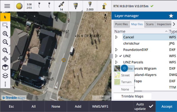
Using Trimble Maps requires no configuration – simply connect the controller to the Internet and the Trimble Maps service can automatically provide background data for the extents of the job. Select from Satellite, Street or Terrain imagery.
The job must use a defined projection and datum. Trimble Maps cannot provide background imagery for jobs that use a Scale factor only or No projection / no datum coordinate system.
Trimble Maps is available with any Trimble Access controller that has a current Trimble Access Software Maintenance Agreement or to any user who has a valid Trimble Access subscription.
For more information, see the topic Trimble Maps in the Trimble Access Help.
Layer manager provides improved linking to design files
Easily link one or more design files at once from Trimble Connect, from a USB drive or from existing folders using the Add button from the Layer manager.
-
For cloud projects, easily select and download files from Trimble Connect, directly from the Layer manager.
-
For USB drives inserted to the controller, files on the USB drive are shown in the file browser, ready to be selected and automatically copied to the project folder on the controller.
-
For SD memory cards inserted to a Windows controller, you can select and use files on the memory card from their current file location.
On Android devices, SD memory cards are treated the same way as USB drives, and files selected from the memory card are copied to the project folder on the controller.
When browsing folders, you can now pin your favorite folders for faster navigation.
Map files linked to the job are now shown as visible in the map when you return to the Layer manager. Point files linked to the job are always shown as visible and selectable when you return to the Layer manager. You can change the visibility or selectability of files and layers as required.
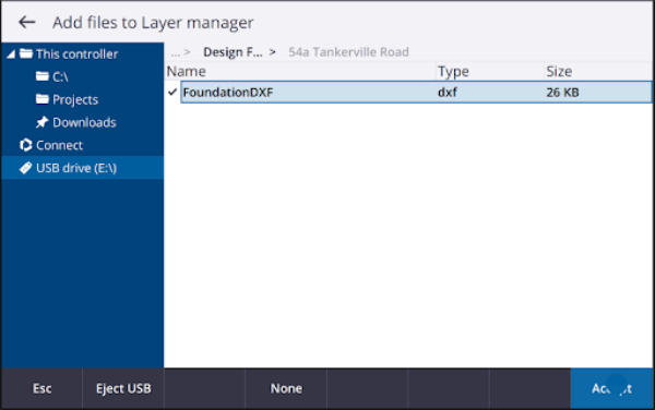
To update a file that has already been linked to the job in Layer manager, you must make sure the new file replaces the previous file of the same name. To do this, make sure Auto update in the Layer manager is enabled, then tap Add and deselect and then reselect the file.
Map tools for working with large datasets
Select and pan in the map
We have consolidated the Select
and Pan
buttons in the Map toolbar, so that you can now select single points and pan in the map without having to tap the Pan button to enter Pan mode.
To pan in the map, make sure Select and pan
For more information, see the topic Map in the Trimble Access Help.
Multiselect button for Rectangle or Polygon selection of multiple map items
Trimble Access 2023.00 includes a new button on the Map toolbar that toggles Rectangle selection and the all-new Polygon selection. Use these selection tools to select multiple items in the map you want to work with, including points and lines, and parts of scan point clouds.
Tap Rectangle selection
and then drag a box around the items you want to select.
Tap Polygon selection
and then tap in the map to start creating a polygon shape around the items you want to select. Keep tapping in the map to add nodes to the polygon. When you are done adding nodes, tap
to close the polygon. The polygon shape disappears from the map and items inside or partially inside the polygon are colored blue to indicate they are selected.
To change toggle between Rectangle selection and Polygon selection mode, tap the button to select it (the button is highlighted) and then tap it again to change mode.
For more information, see the topic Selecting items in the map in the Trimble Access Help.
Show only some items in a BIM model
The new BIM toolbar provides tools for isolating the items in a BIM model you are most interested in.
Select items from the BIM model in the map and then tap Hide
to hide the selected items. Alternatively, tap Show only
to hide everything except the selected items.
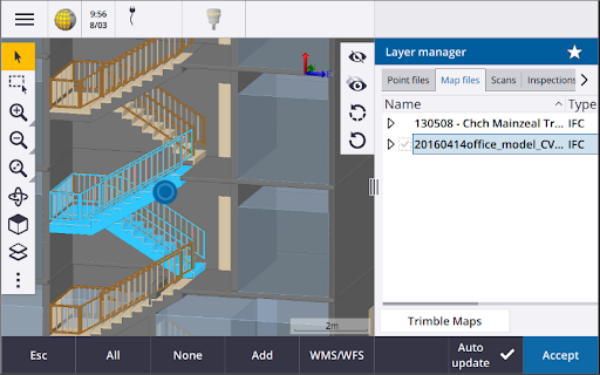
For more information, see the topic Showing only some items in a BIM model in the Trimble Access Help.
Map data transparency
The new Transparency form provides separate transparency controls for BIM models in the map and other map backgrounds including Trimble Maps, data layers from a WMS, and background images. Increased transparency can provide better contrast with features in the job or in other linked files.
To open the Transparency form, tap
and select Transparency.
For more information, see the topic Map data transparency in the Trimble Access Help.
Surface inspection transparency
To remove distracting artifacts from your scan inspections, when setting up the Color scale for a Surface inspection you can now select Transparent for scan points that you do not want to be shown. For example, set the color for scan points outside of the ranges you are interested in to Transparent, so that only points you are interested in are colorized and shown on the map.
For more information, see the topic Surface inspection in the Trimble Access Help.
Other new features and enhancements
Export feature coded symbols as a DXF file
You can now export feature coded symbols to DXF from Trimble Access.
From the Export screen, in the Points and lines field select Feature library symbols to show points, lines, arcs, polylines and polygons using the symbols defined in the Feature library file used for the job. Alternatively, you can choose to export points and lines showing Method symbols or simple dots and lines.
For more information, see the topic To export data from the job in the Trimble Access Help.
Import CSV with configurable delimiter
When importing a CSV file using the Comma Delimited (*.CSV, *.TXT) file format you can now select the Field delimiter that separates the data in your file into distinct fields. The delimiter options include comma, semicolon, colon, space, and tab.
Geotagging images on Android controllers
You can now geotag images when running Trimble Access on an Android controller. Previously, geotagging was supported only on Windows controllers. Geotagging adds information to the properties of the file, including the GPS coordinates of where the image was captured, a timestamp showing when the image was captured, and other relevant information including point ID as the image description and user name.
For more information, see the topic To geotag an image in the Trimble Access Help.
Station stakeout enhancements
Trimble Access 2023.00 includes the following enhancements for staking stations. For more information, see the topic Stations available for stakeout in the Trimble Access Help.
Station selection and settings for lines, arcs, and polylines
When staking stations on a line, arc, or polyline, you can now use the Select station screen to select the station to stake and to define station interval settings. You can:
Define the station interval.
Select the Method used to increment the station interval:
The 0 based method is the default method and gives station values that are multiples of the station interval.
The Relative method gives station values relative to the start station.
Enable the new Auto increment setting enables you to automate the selection of the next (or previous) station.
Auto increment station during stakeout
When staking stations on a line, arc, polyline or alignment the new Auto increment setting enables you to automate the selection of the next (or previous) station for a more streamlined stakeout workflow.
To enable Auto increment, select the stakeout method and then tap
next to the Station field in the Stakeout screen to open the Select station screen and then select Sta+ or Sta- in the Auto increment field. To be able to manually select the required station in the navigation screen, select No in the Auto increment field.
Sharing station interval settings for alignments in IFC files
When staking stations on an alignment, Station interval settings configured in the Select station screen are written to the alignment file so that the same settings are used if the file is shared with other survey crews.
Because Trimble Access cannot write to an IFC file, if the file is an IFC file, then in Trimble Access version 2023.00 onward Station interval settings configured in the Select station screen are written to a Trimble Additional Properties (TAP) file. The TAP file is stored in the same folder as the IFC file of the same name. If other survey crews are using the IFC file, then you can share the .tap file with the .ifc file to ensure all survey crews use the same station interval settings.
Consistent station abbreviations for start and end station
Trimble Access now uses S to denote the Start station and E to denote the End station for lines, polylines, arcs, alignments, roads and tunnels. In previous versions the abbreviations used to denote the start and end station were different for different feature types.
Web map service (WMS) and web feature service (WFS) enhancements
Trimble Access version 2023.00 includes the following enhancements for web map and web feature services (WMS/WFS):
-
WMS and WFS now provide the same enhanced sign in options. You can now select the Sign in method and add credentials and other information required to use the service. Previously, sign in details for a WFS had to be configured and saved to a file using SiteVision Manager.
If you are using a WMS URL that includes sign in credentials as parameters, you can keep the sign in credentials as part of the URL and select None in the Sign in method field. However sign in credentials that are part of the URL are never encrypted. To ensure that your credentials can be encrypted if supported by the server setup, Trimble recommends that you remove the sign in parameters from the URL and select Http Authentication in the Sign in method field and then enter the Username and Password.
-
You can now select the EPSG code from the Coordinate system field when using a WFS. In addition, for both WMS and WFS the software now uses the job coordinate system to determine the most appropriate EPSG code to use from the list of codes provided by the service.
-
Like WMS, WFS now keeps parameters entered by the user in the URL and passes them on to the service. This enables you to enter parameters such as version number, if required.
-
The processing of WMS and WFS data has been improved to support the reading of global/local or grid coordinates based on the EPSG code.
-
To provide better support for servers that provide both WMS & WFS on the same URL, you must now select Web Feature Service (WFS) or Web Map Service (WMS) from the Service type field. Previously, Trimble Access attempted to detect the service type automatically.
For more information, see the topic To manage web map & web feature services (WMS or WFS) in the Trimble Access Help.
No join in CAD toolbar
The No join button on the CAD toolbar has a new icon ![]() to better reflect that the No join function enables you to measure a standalone point that has the same code but is not joined to the previous point or the next point.
to better reflect that the No join function enables you to measure a standalone point that has the same code but is not joined to the previous point or the next point.
For more information, see the topic To create features using control codes in Measure codes in the Trimble Access Help.
Check backsight auto return
When checking the backsight during a conventional survey, if the instrument had automatically turned to the backsight or if you tapped Turn to turn the instrument to the backsight, then when you tap Esc to leave the Check BS screen the instrument will now automatically turn back to the previous HA/VA.
Underground utility locator support for Vivax Metrotech vLoc3-Pro
In Trimble Access 2022.10 we introduced support for the Radio Detection RD8100 cable and pipe locator. In Trimble Access 2023.00 we have added support for another popular model of utility locator, the Vivax Metrotech vLoc3-Pro receiver.
Connect Trimble Access to the vLoc3-Pro and measure the location of underground assets such as cables and pipes.
Because Trimble Access connects to the vLoc3-Pro receiver using Bluetooth, the vLoc3-Pro must be fitted with the vLoc3 Series Bluetooth Module.
The vLoc3.uld file is provided in the C:\ProgramData\
Once you have created a job that uses the FXL file and defined the Utility locator settings in the survey style, you can connect to the utility locator and measure points using the codes configured with attributes to record the depth information from the utility locator.
For more information, see the topic Utility locators in the Trimble Access Help.
Project location and ground coordinates
We have improved the software screen for setting up a ground coordinate system so that you can now key in the ground coordinates of the project location and the software will automatically calculate and display the offsets to the underlying projection grid coordinates for the project location. Alternatively, if you key in the offsets (as required in previous versions of Trimble Access), the resulting ground coordinates of the project location are computed and shown.
For more information, see the topic To set up a ground coordinate system in the Trimble Access Help.
GNSS signal tracking
-
BeiDou tracking is now enabled by default in new GNSS survey styles. GNSS surveys with firmware earlier than version 6.00 must contain either GPS or BeiDou observations. If you disable one, then tracking the other constellation is automatically enabled.
-
You can now enable NavIC signal tracking in real-time kinematic surveys where both the base and rover receivers support IRNSS/NavIC signals for RTK.
TLS encryption for internet data links
Internet data links for GNSS RTK surveys now support the use of Transport Layer Security (TLS) internet data encryption for secure server connections. The Use TLS encryption switch in the Connections tab of the GNSS contact enables this setting. Trimble Access supports TLS version 1.2 or later.
12da point names
Trimble Access can now read the name record for points in a 12da file. The name is displayed in the Code field.
File naming improvements
We have made the following improvements when naming files:
-
International characters are now supported in file names when running Trimble Access on Windows or Android. Previously characters using accents or cyrillic symbols were supported only on Android.
-
The full file path (including file name and folder names) is no longer restricted to 250 characters. However, because other software such as Windows Explorer does have character limits for file paths, Trimble recommends exceeding 250 characters with caution.
Performance improvements
-
You should now see fewer map update delays when changing the visibility or selectability of BIM files or layers in the Layer manager when Auto update is enabled.
-
We have removed the Use Trimble keyboard setting from the Settings / Language screen. The on-screen Trimble keyboard now always automatically appears when you need to enter data in a field in the software, regardless of the operating system of the controller, or whether the controller is operating in Tablet mode.
-
When tapping the screen close to a slider control, the software no longer responds to screen taps at the far left or far right of the slider, and now responds only to screen taps on the slider control or on the slider control labels.
Coordinate System Database updates
The
-
Added SIRGAS‐ROU98 datum and zones for Uruguay.
-
Added old realizations of California Spatial Reference System (CSRS) for California.
-
Added coordinate system zones for Guam.
-
Added coordinate systems for Austria: EPSG 31257, 31258, 31259.
-
Added SIRGAS-Ecuador coordinate system support for Ecuador.
-
Added Kinematic Datum IGS20 and RTX20 (which are considered the same as ITRF 2020).
Positions measured using the Trimble Centerpoint RTX™ correction service are now always computed in the receiver as ITRF 2020 at the epoch of measurement. The time-dependent transformation database installed with Trimble Access now transforms the RTX positions between ITRF 2020 at the epoch of measurement and the global reference frame.
New hardware support
Trimble SX12 Wi‑Fi HaLow support
Trimble Access version 2023.00 introduces support for the Trimble SX12 scanning total station with Wi‑Fi HaLow™, available in the United States, Canada, Australia, and New Zealand. Wi‑Fi HaLow provides a reliable, easy-to-use method for transferring large amounts of data such as point clouds, images, and video at a longer range than standard Wi-Fi™ technology.
When running Trimble Access version 2023.00 on a Trimble controller fitted with an EM130 Wi‑Fi HaLow module, you can connect to a Trimble SX12 scanning total station using Wi‑Fi HaLow from the Wi‑Fi tab in the Connections screen.
For more information, see the topic Wi‑Fi connections in the Trimble Access Help.
Trimble SX12 password support
Wi-Fi or Wi-Fi HaLow connections to a Trimble SX12 scanning total station with firmware S2.8.x or later installed require an instrument password for enhanced security protection.
Trimble Access version 2023.00 supports the configuration of an instrument password for the SX12.
Once you have entered the password for an instrument, the Trimble Access software saves and remembers the password for each instrument you connect to. As long as the password stored in the instrument matches the password for that instrument stored on the controller, you can reconnect to the instrument without having to re-enter the password.
For more information, see the topic Instrument password in the Trimble Access Help.
Trimble EM940 EMPOWER RTK Radio module
Trimble Access version 2023.00 introduces support for the Trimble EM940 EMPOWER RTK Radio module, which enables you to receive GNSS corrections on the 450 MHz and 900 MHz frequency band when using a Trimble GNSS receiver that does not have an internal radio, or which has a radio that is not in the required frequency band.
The EMPOWER RTK Radio module attaches to any supported controller that has an EMPOWER module bay, such as the Trimble TSC7 or TSC5 controller.
For more information, see the topic To configure a rover radio data link in the Trimble Access Help.
Trimble Installation Manager updates
Because job (.job) files created using a previous version of Trimble Access are automatically upgraded when you open them in the latest version of Trimble Access, Trimble Installation Manager no longer upgrades job files as part of the version upgrade process.
The process to upgrade files using Trimble Installation Manager would create a copy of the original files before converting them. Now that Trimble Installation Manager is no longer upgrading the job files, installing a new version of Trimble Access is now faster and requires less disk space. However, there is no backup of the original job files – to keep a copy of the original files that can be used with the earlier version of Trimble Access you must create your own backup copy before opening the job files in the latest version of Trimble Access.
For more information, see Installing Trimble Access in the Trimble Access Help.
Resolved issues
-
Sync scheduler dialog hidden: We have fixed an issue where the Upload local project to cloud dialog was sometimes hidden behind other forms when signing in or moving between forms, which meant that the software stopped automatically uploading data.
-
Background image world files: We have fixed an issue where world files for background images (for example, .jpgw, .pgw or .pngw) were sometimes removed from the controller when the project was synchronized to the cloud.
-
Image naming: We have fixed several issues with image naming, including:
-
When the Link to field is set to None, image files are now renamed even if the Media files screen is open.
-
When the Link to field is set to Next Point, an automatically incrementing number is now only added to the end of the image filename if an image with the same name already exists.
-
Placeholder elements for linking to the next point (such as NextPoint, NextCode) now display in the currently selected language.
-
-
Additional settings from template: We have fixed an issue when creating a new job where the additional settings from a selected template were not copied over to the new job.
-
Import CSV: When importing a CSV file with the Advanced geodetic check box enabled in the Cogo settings screen, the names of the coordinate fields in the Import screen now update when you select a different option from the Coordinate type field.
-
Error in Trimble Business Center on job import: We have fixed an error that could result in a "parameter is invalid parameter name : seconds" message when importing a job containing GNSS data into Trimble Business Center.
-
Hours to UTC value: We have changed the sign of the HoursToUTC value written to JXL files on Android controllers, to make it consistent with the value written to JXL files on Windows controllers. HoursToUTC = UTC - local time.
-
DXF export: We have fixed the following issues when exporting to DXF:
-
The attribute name was included with each point or feature as well as the attribute value. Now, only the attribute value is exported.
-
A separate layer for each text attribute is now created per feature code. Previously attribute text was always written to layer 0 for each code.
-
-
Feature symbols: We have fixed the following issues with drawing feature symbols defined in the feature library file (FXL):
-
Feature symbols defined by the value of an attribute field displayed the symbols for all attribute values rather than the symbol for the selected attribute value.
-
When exporting to DXF, attribute text was always written to layer 0 instead of to the layer for each attribute.
-
Feature symbols that included a half-circle were not drawn correctly in Trimble Access.
-
-
Layer manager visibility settings: We have fixed an issue where if Auto update was enabled and you toggled through the three possible visibility settings for a file or layer in the Features tab before selecting the original visibility setting, then that setting was ignored when you tapped Accept.
-
IFC surface display: We have resolved an occasional issue where tube-like objects were not always displayed correctly.
-
BIM object selection: We have resolved an issue with some BIM models where Surface selection mode was set to Whole object, but only a single face was selected and not the whole object as expected.
-
WFS layer color: WFS layers are now displayed using a consistent color while Trimble Access is open. Previously, changing the layer display in the Layer manager or reopening the job would change the display color used for the WFS layer.
-
WMS images: We have fixed an issue where connections to WMS services would fail to load any background images if the service returned a character set field as part of an image content header.
-
Target height: We have fixed an issue where the Target height field was sometimes missing on the Measure topo form when the instrument was in tracking mode.
-
Measure codes: We have fixed an issue in Measure codes where sometimes the entire contents of the Code field were selected when the Multicode button was active, and other times the cursor was placed at the end of the Code field when switching between Measure forms using a function key.
-
Staking polyline with IFC attributes: Attributes saved to a polyline created from an IFC file are now stored with the points recorded when staking the polyline.
-
Staking to a DTM: When staking relative to a DTM with a Perp. Dist to DTM delta you will no longer see an obviously erroneous delta value when reviewing the job. This was only an issue when your measured position was a long distance from the DTM.
-
Reselecting staked out items in the map: We have fixed an issue where if you staked out a line, arc or polyline where the new staked points used the names of previously deleted staked points, then after storing the item you could not immediately reselect the item in the map after deselecting it.
-
Rectangle control code: After measuring a three-point rectangle, subsequent points are no longer joined to the created rectangle.
-
Improved display of arcs: Arcs defined in a horizontal alignment are now drawn as true arcs. Previously they were draw as a series of short straights. This was a display issue only and did not effect stakeout.
-
0 gon values: We have fixed an issue where angle values of 0 gon were sometimes shown as 400 gon. Now they are consistently shown as 0 gon.
-
NTRIP v2.0 servers: We have fixed issues where Trimble Access would not show a source table from an NTRIP v2.0 server if the server did not specifically declare it was a source table in the NTRIP header Content-Type field, or where correction data from a mountpoint was not used if the Content-Type field was not provided by the server in the response to the mountpoint stream request.
-
SX camera view: We have fixed an issue when using a Trimble SX10 or SX12 scanning total station where sometimes the view from the wrong camera was temporarily shown when you switched camera views in the software.
-
SX Wi-Fi password prompt: We have fixed an issue when using a Trimble SX10 or SX12 scanning total station where sometimes the Trimble Access software prompted you to enter a password if you switched from a long range radio connection to a Wi-Fi connection.
-
Resection: We have fixed an issue where codes keyed in before a backsight measurement was taken during a resection were not being used when measuring the backsight point.
-
ISO Rounds report: We fixed an issue in the ISO Rounds report where the Mean out of all sets column could contain erroneous values when the observations averaged are either side of 360 and 0 degrees.
-
Integrated survey: If you have configured Function keys to Auto-switch between GNSS and conventional surveying, the software now switches reliably between GNSS and conventional surveys when you press the appropriate Fn key.
-
Integrated survey resection points: A fix recorded in the Trimble Access version 2022.10 release notes was unfortunately incomplete. We believe we have now fixed an issue when performing a resection in an integrated survey, where if you attempted to measure an observation to a point that did not yet exist in the job, when the software switched to the GNSS measure screen it also changed the point name to the next point name in the GNSS point sequence, rather than retaining the name you had entered for the conventional point.
-
Software configuration when running in Japanese: When installing Trimble Access for the first time in Japanese only the Metric template is created. When running Trimble Access in Japanese the software now only shows units and coordinate systems applicable for Japan.
-
Application errors: We have fixed several issues that caused occasional application errors when using or closing the software. In particular:
-
Trimble Access would sometimes become unresponsive when using the Sync scheduler to automatically upload to synchronize large projects to the cloud.
-
When keying in a line, arc, or polyline where the station interval was too small for the length of the line.
-
When staking a polyline using the Side slope from polyline stake method where one or more fields had null values.
-
During stakeout the software would sometimes show an application error "HOOPS Error: Requested shell has non-usable values" and shut down.
-
When assigning a feature code to a line where the symbol for the feature code consisted of repeating short arcs.
-
When offsetting a closed polyline with duplicate vertices in a DWG file.
-
When connected to a Trimble SX10 or SX12 scanning total station, occasionally the software would show there was an error updating wireless settings and would close the Instrument settings screen when you attempted to change the Wi-Fi channel.
-
When connected to a Trimble SX10 or SX12 scanning total station, sometimes the software would unexpectedly close after you suspended and then resumed the controller when Trimble Access was running and the Video screen was open.
-
Occasionally the software would lock up on shut down when running on a TCU5 controller connected to a Trimble S Series total station.
-
Occasionally the software would show an application error when attempting to configure Wi-Fi settings for a Spectra Geospatial SP80 receiver.
-
When calculating an RTK/RTX offset and selecting one of the points from the list instead of keying in the point ID.
-
When using stakeout polyline in a job with a Broadcast RTCM coordinate system.
-
When selecting the TWD97 coordinate system when running Trimble Access on a TCU5 controller.
- When using a less widely-used Trimble Access app such as Land Seismic, and:
- Connecting to a receiver that was generating RTX-corrected positions before opening a job.
- Staking out entities where the app reported live information in custom stakeout fields.
-
